Get trending papers in your email inbox once a day!
Get trending papers in your email inbox!
Subscribe


KERPLE: Kernelized Relative Positional Embedding for Length Extrapolation
Relative positional embeddings (RPE) have received considerable attention since RPEs effectively model the relative distance among tokens and enable length extrapolation. We propose KERPLE, a framework that generalizes relative position embedding for extrapolation by kernelizing positional differences. We achieve this goal using conditionally positive definite (CPD) kernels, a class of functions known for generalizing distance metrics. To maintain the inner product interpretation of self-attention, we show that a CPD kernel can be transformed into a PD kernel by adding a constant offset. This offset is implicitly absorbed in the Softmax normalization during self-attention. The diversity of CPD kernels allows us to derive various RPEs that enable length extrapolation in a principled way. Experiments demonstrate that the logarithmic variant achieves excellent extrapolation performance on three large language modeling datasets. Our implementation and pretrained checkpoints are released at https://github.com/chijames/KERPLE.git.
Rethinking and Improving Relative Position Encoding for Vision Transformer
Relative position encoding (RPE) is important for transformer to capture sequence ordering of input tokens. General efficacy has been proven in natural language processing. However, in computer vision, its efficacy is not well studied and even remains controversial, e.g., whether relative position encoding can work equally well as absolute position? In order to clarify this, we first review existing relative position encoding methods and analyze their pros and cons when applied in vision transformers. We then propose new relative position encoding methods dedicated to 2D images, called image RPE (iRPE). Our methods consider directional relative distance modeling as well as the interactions between queries and relative position embeddings in self-attention mechanism. The proposed iRPE methods are simple and lightweight. They can be easily plugged into transformer blocks. Experiments demonstrate that solely due to the proposed encoding methods, DeiT and DETR obtain up to 1.5% (top-1 Acc) and 1.3% (mAP) stable improvements over their original versions on ImageNet and COCO respectively, without tuning any extra hyperparameters such as learning rate and weight decay. Our ablation and analysis also yield interesting findings, some of which run counter to previous understanding. Code and models are open-sourced at https://github.com/microsoft/Cream/tree/main/iRPE.

Supervised Metric Learning to Rank for Retrieval via Contextual Similarity Optimization
There is extensive interest in metric learning methods for image retrieval. Many metric learning loss functions focus on learning a correct ranking of training samples, but strongly overfit semantically inconsistent labels and require a large amount of data. To address these shortcomings, we propose a new metric learning method, called contextual loss, which optimizes contextual similarity in addition to cosine similarity. Our contextual loss implicitly enforces semantic consistency among neighbors while converging to the correct ranking. We empirically show that the proposed loss is more robust to label noise, and is less prone to overfitting even when a large portion of train data is withheld. Extensive experiments demonstrate that our method achieves a new state-of-the-art across four image retrieval benchmarks and multiple different evaluation settings. Code is available at: https://github.com/Chris210634/metric-learning-using-contextual-similarity

ConTextual: Evaluating Context-Sensitive Text-Rich Visual Reasoning in Large Multimodal Models
Recent advancements in AI have led to the development of large multimodal models (LMMs) capable of processing complex tasks involving joint reasoning over text and visual content in the image (e.g., navigating maps in public places). This paper introduces ConTextual, a novel benchmark comprising instructions designed explicitly to evaluate LMMs' ability to perform context-sensitive text-rich visual reasoning. ConTextual emphasizes diverse real-world scenarios (e.g., time-reading, navigation, shopping and more) demanding a deeper understanding of the interactions between textual and visual elements. Our findings reveal a significant performance gap of 30.8% between the best-performing LMM, GPT-4V(ision), and human capabilities using human evaluation indicating substantial room for improvement in context-sensitive text-rich visual reasoning. Notably, while GPT-4V excelled in abstract categories like meme and quote interpretation, its overall performance still lagged behind humans. In addition to human evaluations, we also employed automatic evaluation metrics using GPT-4, uncovering similar trends in performance disparities. We also perform a fine-grained evaluation across diverse visual contexts and provide qualitative analysis which provides a robust framework for future advancements in the LMM design. https://con-textual.github.io/


GeoLM: Empowering Language Models for Geospatially Grounded Language Understanding
Humans subconsciously engage in geospatial reasoning when reading articles. We recognize place names and their spatial relations in text and mentally associate them with their physical locations on Earth. Although pretrained language models can mimic this cognitive process using linguistic context, they do not utilize valuable geospatial information in large, widely available geographical databases, e.g., OpenStreetMap. This paper introduces GeoLM, a geospatially grounded language model that enhances the understanding of geo-entities in natural language. GeoLM leverages geo-entity mentions as anchors to connect linguistic information in text corpora with geospatial information extracted from geographical databases. GeoLM connects the two types of context through contrastive learning and masked language modeling. It also incorporates a spatial coordinate embedding mechanism to encode distance and direction relations to capture geospatial context. In the experiment, we demonstrate that GeoLM exhibits promising capabilities in supporting toponym recognition, toponym linking, relation extraction, and geo-entity typing, which bridge the gap between natural language processing and geospatial sciences. The code is publicly available at https://github.com/knowledge-computing/geolm.

G3: An Effective and Adaptive Framework for Worldwide Geolocalization Using Large Multi-Modality Models
Worldwide geolocalization aims to locate the precise location at the coordinate level of photos taken anywhere on the Earth. It is very challenging due to 1) the difficulty of capturing subtle location-aware visual semantics, and 2) the heterogeneous geographical distribution of image data. As a result, existing studies have clear limitations when scaled to a worldwide context. They may easily confuse distant images with similar visual contents, or cannot adapt to various locations worldwide with different amounts of relevant data. To resolve these limitations, we propose G3, a novel framework based on Retrieval-Augmented Generation (RAG). In particular, G3 consists of three steps, i.e., Geo-alignment, Geo-diversification, and Geo-verification to optimize both retrieval and generation phases of worldwide geolocalization. During Geo-alignment, our solution jointly learns expressive multi-modal representations for images, GPS and textual descriptions, which allows us to capture location-aware semantics for retrieving nearby images for a given query. During Geo-diversification, we leverage a prompt ensembling method that is robust to inconsistent retrieval performance for different image queries. Finally, we combine both retrieved and generated GPS candidates in Geo-verification for location prediction. Experiments on two well-established datasets IM2GPS3k and YFCC4k verify the superiority of G3 compared to other state-of-the-art methods.
Context Matters for Image Descriptions for Accessibility: Challenges for Referenceless Evaluation Metrics
Few images on the Web receive alt-text descriptions that would make them accessible to blind and low vision (BLV) users. Image-based NLG systems have progressed to the point where they can begin to address this persistent societal problem, but these systems will not be fully successful unless we evaluate them on metrics that guide their development correctly. Here, we argue against current referenceless metrics -- those that don't rely on human-generated ground-truth descriptions -- on the grounds that they do not align with the needs of BLV users. The fundamental shortcoming of these metrics is that they do not take context into account, whereas contextual information is highly valued by BLV users. To substantiate these claims, we present a study with BLV participants who rated descriptions along a variety of dimensions. An in-depth analysis reveals that the lack of context-awareness makes current referenceless metrics inadequate for advancing image accessibility. As a proof-of-concept, we provide a contextual version of the referenceless metric CLIPScore which begins to address the disconnect to the BLV data. An accessible HTML version of this paper is available at https://elisakreiss.github.io/contextual-description-evaluation/paper/reflessmetrics.html

Composed Image Retrieval for Remote Sensing
This work introduces composed image retrieval to remote sensing. It allows to query a large image archive by image examples alternated by a textual description, enriching the descriptive power over unimodal queries, either visual or textual. Various attributes can be modified by the textual part, such as shape, color, or context. A novel method fusing image-to-image and text-to-image similarity is introduced. We demonstrate that a vision-language model possesses sufficient descriptive power and no further learning step or training data are necessary. We present a new evaluation benchmark focused on color, context, density, existence, quantity, and shape modifications. Our work not only sets the state-of-the-art for this task, but also serves as a foundational step in addressing a gap in the field of remote sensing image retrieval. Code at: https://github.com/billpsomas/rscir


Large Language Models for Next Point-of-Interest Recommendation
The next Point of Interest (POI) recommendation task is to predict users' immediate next POI visit given their historical data. Location-Based Social Network (LBSN) data, which is often used for the next POI recommendation task, comes with challenges. One frequently disregarded challenge is how to effectively use the abundant contextual information present in LBSN data. Previous methods are limited by their numerical nature and fail to address this challenge. In this paper, we propose a framework that uses pretrained Large Language Models (LLMs) to tackle this challenge. Our framework allows us to preserve heterogeneous LBSN data in its original format, hence avoiding the loss of contextual information. Furthermore, our framework is capable of comprehending the inherent meaning of contextual information due to the inclusion of commonsense knowledge. In experiments, we test our framework on three real-world LBSN datasets. Our results show that the proposed framework outperforms the state-of-the-art models in all three datasets. Our analysis demonstrates the effectiveness of the proposed framework in using contextual information as well as alleviating the commonly encountered cold-start and short trajectory problems.
PointNet++: Deep Hierarchical Feature Learning on Point Sets in a Metric Space
Few prior works study deep learning on point sets. PointNet by Qi et al. is a pioneer in this direction. However, by design PointNet does not capture local structures induced by the metric space points live in, limiting its ability to recognize fine-grained patterns and generalizability to complex scenes. In this work, we introduce a hierarchical neural network that applies PointNet recursively on a nested partitioning of the input point set. By exploiting metric space distances, our network is able to learn local features with increasing contextual scales. With further observation that point sets are usually sampled with varying densities, which results in greatly decreased performance for networks trained on uniform densities, we propose novel set learning layers to adaptively combine features from multiple scales. Experiments show that our network called PointNet++ is able to learn deep point set features efficiently and robustly. In particular, results significantly better than state-of-the-art have been obtained on challenging benchmarks of 3D point clouds.
IsoScore: Measuring the Uniformity of Embedding Space Utilization
The recent success of distributed word representations has led to an increased interest in analyzing the properties of their spatial distribution. Several studies have suggested that contextualized word embedding models do not isotropically project tokens into vector space. However, current methods designed to measure isotropy, such as average random cosine similarity and the partition score, have not been thoroughly analyzed and are not appropriate for measuring isotropy. We propose IsoScore: a novel tool that quantifies the degree to which a point cloud uniformly utilizes the ambient vector space. Using rigorously designed tests, we demonstrate that IsoScore is the only tool available in the literature that accurately measures how uniformly distributed variance is across dimensions in vector space. Additionally, we use IsoScore to challenge a number of recent conclusions in the NLP literature that have been derived using brittle metrics of isotropy. We caution future studies from using existing tools to measure isotropy in contextualized embedding space as resulting conclusions will be misleading or altogether inaccurate.

Where We Are and What We're Looking At: Query Based Worldwide Image Geo-localization Using Hierarchies and Scenes
Determining the exact latitude and longitude that a photo was taken is a useful and widely applicable task, yet it remains exceptionally difficult despite the accelerated progress of other computer vision tasks. Most previous approaches have opted to learn a single representation of query images, which are then classified at different levels of geographic granularity. These approaches fail to exploit the different visual cues that give context to different hierarchies, such as the country, state, and city level. To this end, we introduce an end-to-end transformer-based architecture that exploits the relationship between different geographic levels (which we refer to as hierarchies) and the corresponding visual scene information in an image through hierarchical cross-attention. We achieve this by learning a query for each geographic hierarchy and scene type. Furthermore, we learn a separate representation for different environmental scenes, as different scenes in the same location are often defined by completely different visual features. We achieve state of the art street level accuracy on 4 standard geo-localization datasets : Im2GPS, Im2GPS3k, YFCC4k, and YFCC26k, as well as qualitatively demonstrate how our method learns different representations for different visual hierarchies and scenes, which has not been demonstrated in the previous methods. These previous testing datasets mostly consist of iconic landmarks or images taken from social media, which makes them either a memorization task, or biased towards certain places. To address this issue we introduce a much harder testing dataset, Google-World-Streets-15k, comprised of images taken from Google Streetview covering the whole planet and present state of the art results. Our code will be made available in the camera-ready version.
Bi-directional Contextual Attention for 3D Dense Captioning
3D dense captioning is a task involving the localization of objects and the generation of descriptions for each object in a 3D scene. Recent approaches have attempted to incorporate contextual information by modeling relationships with object pairs or aggregating the nearest neighbor features of an object. However, the contextual information constructed in these scenarios is limited in two aspects: first, objects have multiple positional relationships that exist across the entire global scene, not only near the object itself. Second, it faces with contradicting objectives--where localization and attribute descriptions are generated better with tight localization, while descriptions involving global positional relations are generated better with contextualized features of the global scene. To overcome this challenge, we introduce BiCA, a transformer encoder-decoder pipeline that engages in 3D dense captioning for each object with Bi-directional Contextual Attention. Leveraging parallelly decoded instance queries for objects and context queries for non-object contexts, BiCA generates object-aware contexts, where the contexts relevant to each object is summarized, and context-aware objects, where the objects relevant to the summarized object-aware contexts are aggregated. This extension relieves previous methods from the contradicting objectives, enhancing both localization performance and enabling the aggregation of contextual features throughout the global scene; thus improving caption generation performance simultaneously. Extensive experiments on two of the most widely-used 3D dense captioning datasets demonstrate that our proposed method achieves a significant improvement over prior methods.
Approximate Nearest Neighbor Search with Window Filters
We define and investigate the problem of c-approximate window search: approximate nearest neighbor search where each point in the dataset has a numeric label, and the goal is to find nearest neighbors to queries within arbitrary label ranges. Many semantic search problems, such as image and document search with timestamp filters, or product search with cost filters, are natural examples of this problem. We propose and theoretically analyze a modular tree-based framework for transforming an index that solves the traditional c-approximate nearest neighbor problem into a data structure that solves window search. On standard nearest neighbor benchmark datasets equipped with random label values, adversarially constructed embeddings, and image search embeddings with real timestamps, we obtain up to a 75times speedup over existing solutions at the same level of recall.

Enhancing Worldwide Image Geolocation by Ensembling Satellite-Based Ground-Level Attribute Predictors
Geolocating images of a ground-level scene entails estimating the location on Earth where the picture was taken, in absence of GPS or other location metadata. Typically, methods are evaluated by measuring the Great Circle Distance (GCD) between a predicted location and ground truth. However, this measurement is limited because it only evaluates a single point, not estimates of regions or score heatmaps. This is especially important in applications to rural, wilderness and under-sampled areas, where finding the exact location may not be possible, and when used in aggregate systems that progressively narrow down locations. In this paper, we introduce a novel metric, Recall vs Area (RvA), which measures the accuracy of estimated distributions of locations. RvA treats image geolocation results similarly to document retrieval, measuring recall as a function of area: For a ranked list of (possibly non-contiguous) predicted regions, we measure the accumulated area required for the region to contain the ground truth coordinate. This produces a curve similar to a precision-recall curve, where "precision" is replaced by square kilometers area, allowing evaluation of performance for different downstream search area budgets. Following directly from this view of the problem, we then examine a simple ensembling approach to global-scale image geolocation, which incorporates information from multiple sources to help address domain shift, and can readily incorporate multiple models, attribute predictors, and data sources. We study its effectiveness by combining the geolocation models GeoEstimation and the current SOTA GeoCLIP, with attribute predictors based on ORNL LandScan and ESA-CCI Land Cover. We find significant improvements in image geolocation for areas that are under-represented in the training set, particularly non-urban areas, on both Im2GPS3k and Street View images.

Yes, we CANN: Constrained Approximate Nearest Neighbors for local feature-based visual localization
Large-scale visual localization systems continue to rely on 3D point clouds built from image collections using structure-from-motion. While the 3D points in these models are represented using local image features, directly matching a query image's local features against the point cloud is challenging due to the scale of the nearest-neighbor search problem. Many recent approaches to visual localization have thus proposed a hybrid method, where first a global (per image) embedding is used to retrieve a small subset of database images, and local features of the query are matched only against those. It seems to have become common belief that global embeddings are critical for said image-retrieval in visual localization, despite the significant downside of having to compute two feature types for each query image. In this paper, we take a step back from this assumption and propose Constrained Approximate Nearest Neighbors (CANN), a joint solution of k-nearest-neighbors across both the geometry and appearance space using only local features. We first derive the theoretical foundation for k-nearest-neighbor retrieval across multiple metrics and then showcase how CANN improves visual localization. Our experiments on public localization benchmarks demonstrate that our method significantly outperforms both state-of-the-art global feature-based retrieval and approaches using local feature aggregation schemes. Moreover, it is an order of magnitude faster in both index and query time than feature aggregation schemes for these datasets. Code will be released.
MNet-Sim: A Multi-layered Semantic Similarity Network to Evaluate Sentence Similarity
Similarity is a comparative-subjective measure that varies with the domain within which it is considered. In several NLP applications such as document classification, pattern recognition, chatbot question-answering, sentiment analysis, etc., identifying an accurate similarity score for sentence pairs has become a crucial area of research. In the existing models that assess similarity, the limitation of effectively computing this similarity based on contextual comparisons, the localization due to the centering theory, and the lack of non-semantic textual comparisons have proven to be drawbacks. Hence, this paper presents a multi-layered semantic similarity network model built upon multiple similarity measures that render an overall sentence similarity score based on the principles of Network Science, neighboring weighted relational edges, and a proposed extended node similarity computation formula. The proposed multi-layered network model was evaluated and tested against established state-of-the-art models and is shown to have demonstrated better performance scores in assessing sentence similarity.
Is It Really Long Context if All You Need Is Retrieval? Towards Genuinely Difficult Long Context NLP
Improvements in language models' capabilities have pushed their applications towards longer contexts, making long-context evaluation and development an active research area. However, many disparate use-cases are grouped together under the umbrella term of "long-context", defined simply by the total length of the model's input, including - for example - Needle-in-a-Haystack tasks, book summarization, and information aggregation. Given their varied difficulty, in this position paper we argue that conflating different tasks by their context length is unproductive. As a community, we require a more precise vocabulary to understand what makes long-context tasks similar or different. We propose to unpack the taxonomy of long-context based on the properties that make them more difficult with longer contexts. We propose two orthogonal axes of difficulty: (I) Diffusion: How hard is it to find the necessary information in the context? (II) Scope: How much necessary information is there to find? We survey the literature on long-context, provide justification for this taxonomy as an informative descriptor, and situate the literature with respect to it. We conclude that the most difficult and interesting settings, whose necessary information is very long and highly diffused within the input, is severely under-explored. By using a descriptive vocabulary and discussing the relevant properties of difficulty in long-context, we can implement more informed research in this area. We call for a careful design of tasks and benchmarks with distinctly long context, taking into account the characteristics that make it qualitatively different from shorter context.


GAEA: A Geolocation Aware Conversational Model
Image geolocalization, in which, traditionally, an AI model predicts the precise GPS coordinates of an image is a challenging task with many downstream applications. However, the user cannot utilize the model to further their knowledge other than the GPS coordinate; the model lacks an understanding of the location and the conversational ability to communicate with the user. In recent days, with tremendous progress of large multimodal models (LMMs) proprietary and open-source researchers have attempted to geolocalize images via LMMs. However, the issues remain unaddressed; beyond general tasks, for more specialized downstream tasks, one of which is geolocalization, LMMs struggle. In this work, we propose to solve this problem by introducing a conversational model GAEA that can provide information regarding the location of an image, as required by a user. No large-scale dataset enabling the training of such a model exists. Thus we propose a comprehensive dataset GAEA with 800K images and around 1.6M question answer pairs constructed by leveraging OpenStreetMap (OSM) attributes and geographical context clues. For quantitative evaluation, we propose a diverse benchmark comprising 4K image-text pairs to evaluate conversational capabilities equipped with diverse question types. We consider 11 state-of-the-art open-source and proprietary LMMs and demonstrate that GAEA significantly outperforms the best open-source model, LLaVA-OneVision by 25.69% and the best proprietary model, GPT-4o by 8.28%. Our dataset, model and codes are available


LD-SDM: Language-Driven Hierarchical Species Distribution Modeling
We focus on the problem of species distribution modeling using global-scale presence-only data. Most previous studies have mapped the range of a given species using geographical and environmental features alone. To capture a stronger implicit relationship between species, we encode the taxonomic hierarchy of species using a large language model. This enables range mapping for any taxonomic rank and unseen species without additional supervision. Further, we propose a novel proximity-aware evaluation metric that enables evaluating species distribution models using any pixel-level representation of ground-truth species range map. The proposed metric penalizes the predictions of a model based on its proximity to the ground truth. We describe the effectiveness of our model by systematically evaluating on the task of species range prediction, zero-shot prediction and geo-feature regression against the state-of-the-art. Results show our model outperforms the strong baselines when trained with a variety of multi-label learning losses.

Weatherproofing Retrieval for Localization with Generative AI and Geometric Consistency
State-of-the-art visual localization approaches generally rely on a first image retrieval step whose role is crucial. Yet, retrieval often struggles when facing varying conditions, due to e.g. weather or time of day, with dramatic consequences on the visual localization accuracy. In this paper, we improve this retrieval step and tailor it to the final localization task. Among the several changes we advocate for, we propose to synthesize variants of the training set images, obtained from generative text-to-image models, in order to automatically expand the training set towards a number of nameable variations that particularly hurt visual localization. After expanding the training set, we propose a training approach that leverages the specificities and the underlying geometry of this mix of real and synthetic images. We experimentally show that those changes translate into large improvements for the most challenging visual localization datasets. Project page: https://europe.naverlabs.com/ret4loc


SPHERE: A Hierarchical Evaluation on Spatial Perception and Reasoning for Vision-Language Models
Current vision-language models may incorporate single-dimensional spatial cues, such as depth, object boundary, and basic spatial directions (e.g. left, right, front, back), yet often lack the multi-dimensional spatial reasoning necessary for human-like understanding and real-world applications. To address this gap, we develop SPHERE (Spatial Perception and Hierarchical Evaluation of REasoning), a hierarchical evaluation framework with a new human-annotated dataset to pinpoint model strengths and weaknesses, advancing from single-skill tasks to multi-skill tasks, and ultimately to complex reasoning tasks that require the integration of multiple spatial and visual cues with logical reasoning. Benchmark evaluation of state-of-the-art open-source models reveal significant shortcomings, especially in the abilities to understand distance and proximity, to reason from both allocentric and egocentric viewpoints, and to perform complex reasoning in a physical context. This work underscores the need for more advanced approaches to spatial understanding and reasoning, paving the way for improvements in vision-language models and their alignment with human-like spatial capabilities. The dataset will be open-sourced upon publication.


Reframing Spatial Reasoning Evaluation in Language Models: A Real-World Simulation Benchmark for Qualitative Reasoning
Spatial reasoning plays a vital role in both human cognition and machine intelligence, prompting new research into language models' (LMs) capabilities in this regard. However, existing benchmarks reveal shortcomings in evaluating qualitative spatial reasoning (QSR). These benchmarks typically present oversimplified scenarios or unclear natural language descriptions, hindering effective evaluation. We present a novel benchmark for assessing QSR in LMs, which is grounded in realistic 3D simulation data, offering a series of diverse room layouts with various objects and their spatial relationships. This approach provides a more detailed and context-rich narrative for spatial reasoning evaluation, diverging from traditional, toy-task-oriented scenarios. Our benchmark encompasses a broad spectrum of qualitative spatial relationships, including topological, directional, and distance relations. These are presented with different viewing points, varied granularities, and density of relation constraints to mimic real-world complexities. A key contribution is our logic-based consistency-checking tool, which enables the assessment of multiple plausible solutions, aligning with real-world scenarios where spatial relationships are often open to interpretation. Our benchmark evaluation of advanced LMs reveals their strengths and limitations in spatial reasoning. They face difficulties with multi-hop spatial reasoning and interpreting a mix of different view descriptions, pointing to areas for future improvement.
MoverScore: Text Generation Evaluating with Contextualized Embeddings and Earth Mover Distance
A robust evaluation metric has a profound impact on the development of text generation systems. A desirable metric compares system output against references based on their semantics rather than surface forms. In this paper we investigate strategies to encode system and reference texts to devise a metric that shows a high correlation with human judgment of text quality. We validate our new metric, namely MoverScore, on a number of text generation tasks including summarization, machine translation, image captioning, and data-to-text generation, where the outputs are produced by a variety of neural and non-neural systems. Our findings suggest that metrics combining contextualized representations with a distance measure perform the best. Such metrics also demonstrate strong generalization capability across tasks. For ease-of-use we make our metrics available as web service.
Can Transformers Capture Spatial Relations between Objects?
Spatial relationships between objects represent key scene information for humans to understand and interact with the world. To study the capability of current computer vision systems to recognize physically grounded spatial relations, we start by proposing precise relation definitions that permit consistently annotating a benchmark dataset. Despite the apparent simplicity of this task relative to others in the recognition literature, we observe that existing approaches perform poorly on this benchmark. We propose new approaches exploiting the long-range attention capabilities of transformers for this task, and evaluating key design principles. We identify a simple "RelatiViT" architecture and demonstrate that it outperforms all current approaches. To our knowledge, this is the first method to convincingly outperform naive baselines on spatial relation prediction in in-the-wild settings. The code and datasets are available in https://sites.google.com/view/spatial-relation.
The Impacts of Data, Ordering, and Intrinsic Dimensionality on Recall in Hierarchical Navigable Small Worlds
Vector search systems, pivotal in AI applications, often rely on the Hierarchical Navigable Small Worlds (HNSW) algorithm. However, the behaviour of HNSW under real-world scenarios using vectors generated with deep learning models remains under-explored. Existing Approximate Nearest Neighbours (ANN) benchmarks and research typically has an over-reliance on simplistic datasets like MNIST or SIFT1M and fail to reflect the complexity of current use-cases. Our investigation focuses on HNSW's efficacy across a spectrum of datasets, including synthetic vectors tailored to mimic specific intrinsic dimensionalities, widely-used retrieval benchmarks with popular embedding models, and proprietary e-commerce image data with CLIP models. We survey the most popular HNSW vector databases and collate their default parameters to provide a realistic fixed parameterisation for the duration of the paper. We discover that the recall of approximate HNSW search, in comparison to exact K Nearest Neighbours (KNN) search, is linked to the vector space's intrinsic dimensionality and significantly influenced by the data insertion sequence. Our methodology highlights how insertion order, informed by measurable properties such as the pointwise Local Intrinsic Dimensionality (LID) or known categories, can shift recall by up to 12 percentage points. We also observe that running popular benchmark datasets with HNSW instead of KNN can shift rankings by up to three positions for some models. This work underscores the need for more nuanced benchmarks and design considerations in developing robust vector search systems using approximate vector search algorithms. This study presents a number of scenarios with varying real world applicability which aim to better increase understanding and future development of ANN algorithms and embedding


On the token distance modeling ability of higher RoPE attention dimension
Length extrapolation algorithms based on Rotary position embedding (RoPE) have shown promising results in extending the context length of language models. However, understanding how position embedding can capture longer-range contextual information remains elusive. Based on the intuition that different dimensions correspond to different frequency of changes in RoPE encoding, we conducted a dimension-level analysis to investigate the correlation between a hidden dimension of an attention head and its contribution to capturing long-distance dependencies. Using our correlation metric, we identified a particular type of attention heads, which we named Positional Heads, from various length-extrapolated models. These heads exhibit a strong focus on long-range information interaction and play a pivotal role in long input processing, as evidence by our ablation. We further demonstrate the correlation between the efficiency of length extrapolation and the extension of the high-dimensional attention allocation of these heads. The identification of Positional Heads provides insights for future research in long-text comprehension.

Calibrating Panoramic Depth Estimation for Practical Localization and Mapping
The absolute depth values of surrounding environments provide crucial cues for various assistive technologies, such as localization, navigation, and 3D structure estimation. We propose that accurate depth estimated from panoramic images can serve as a powerful and light-weight input for a wide range of downstream tasks requiring 3D information. While panoramic images can easily capture the surrounding context from commodity devices, the estimated depth shares the limitations of conventional image-based depth estimation; the performance deteriorates under large domain shifts and the absolute values are still ambiguous to infer from 2D observations. By taking advantage of the holistic view, we mitigate such effects in a self-supervised way and fine-tune the network with geometric consistency during the test phase. Specifically, we construct a 3D point cloud from the current depth prediction and project the point cloud at various viewpoints or apply stretches on the current input image to generate synthetic panoramas. Then we minimize the discrepancy of the 3D structure estimated from synthetic images without collecting additional data. We empirically evaluate our method in robot navigation and map-free localization where our method shows large performance enhancements. Our calibration method can therefore widen the applicability under various external conditions, serving as a key component for practical panorama-based machine vision systems.
Speech Commands: A Dataset for Limited-Vocabulary Speech Recognition
Describes an audio dataset of spoken words designed to help train and evaluate keyword spotting systems. Discusses why this task is an interesting challenge, and why it requires a specialized dataset that is different from conventional datasets used for automatic speech recognition of full sentences. Suggests a methodology for reproducible and comparable accuracy metrics for this task. Describes how the data was collected and verified, what it contains, previous versions and properties. Concludes by reporting baseline results of models trained on this dataset.
ContextRef: Evaluating Referenceless Metrics For Image Description Generation
Referenceless metrics (e.g., CLIPScore) use pretrained vision--language models to assess image descriptions directly without costly ground-truth reference texts. Such methods can facilitate rapid progress, but only if they truly align with human preference judgments. In this paper, we introduce ContextRef, a benchmark for assessing referenceless metrics for such alignment. ContextRef has two components: human ratings along a variety of established quality dimensions, and ten diverse robustness checks designed to uncover fundamental weaknesses. A crucial aspect of ContextRef is that images and descriptions are presented in context, reflecting prior work showing that context is important for description quality. Using ContextRef, we assess a variety of pretrained models, scoring functions, and techniques for incorporating context. None of the methods is successful with ContextRef, but we show that careful fine-tuning yields substantial improvements. ContextRef remains a challenging benchmark though, in large part due to the challenge of context dependence.

RoboSpatial: Teaching Spatial Understanding to 2D and 3D Vision-Language Models for Robotics
Spatial understanding is a crucial capability for robots to make grounded decisions based on their environment. This foundational skill enables robots not only to perceive their surroundings but also to reason about and interact meaningfully within the world. In modern robotics, these capabilities are taken on by visual language models, and they face significant challenges when applied to spatial reasoning context due to their training data sources. These sources utilize general-purpose image datasets, and they often lack sophisticated spatial scene understanding capabilities. For example, the datasets do not address reference frame comprehension - spatial relationships require clear contextual understanding, whether from an ego-centric, object-centric, or world-centric perspective, which allow for effective real-world interaction. To address this issue, we introduce RoboSpatial, a large-scale spatial understanding dataset consisting of real indoor and tabletop scenes captured as 3D scans and egocentric images, annotated with rich spatial information relevant to robotics. The dataset includes 1M images, 5K 3D scans, and 3M annotated spatial relationships, with paired 2D egocentric images and 3D scans to make it both 2D and 3D ready. Our experiments show that models trained with RoboSpatial outperform baselines on downstream tasks such as spatial affordance prediction, spatial relationship prediction, and robotics manipulation.

MovieNet-PS: A Large-Scale Person Search Dataset in the Wild
Person search aims to jointly localize and identify a query person from natural, uncropped images, which has been actively studied over the past few years. In this paper, we delve into the rich context information globally and locally surrounding the target person, which we refer to as scene and group context, respectively. Unlike previous works that treat the two types of context individually, we exploit them in a unified global-local context network (GLCNet) with the intuitive aim of feature enhancement. Specifically, re-ID embeddings and context features are simultaneously learned in a multi-stage fashion, ultimately leading to enhanced, discriminative features for person search. We conduct the experiments on two person search benchmarks (i.e., CUHK-SYSU and PRW) as well as extend our approach to a more challenging setting (i.e., character search on MovieNet). Extensive experimental results demonstrate the consistent improvement of the proposed GLCNet over the state-of-the-art methods on all three datasets. Our source codes, pre-trained models, and the new dataset are publicly available at: https://github.com/ZhengPeng7/GLCNet.

MARRS: Multimodal Reference Resolution System
Successfully handling context is essential for any dialog understanding task. This context maybe be conversational (relying on previous user queries or system responses), visual (relying on what the user sees, for example, on their screen), or background (based on signals such as a ringing alarm or playing music). In this work, we present an overview of MARRS, or Multimodal Reference Resolution System, an on-device framework within a Natural Language Understanding system, responsible for handling conversational, visual and background context. In particular, we present different machine learning models to enable handing contextual queries; specifically, one to enable reference resolution, and one to handle context via query rewriting. We also describe how these models complement each other to form a unified, coherent, lightweight system that can understand context while preserving user privacy.

Evaluation of Geographical Distortions in Language Models: A Crucial Step Towards Equitable Representations
Language models now constitute essential tools for improving efficiency for many professional tasks such as writing, coding, or learning. For this reason, it is imperative to identify inherent biases. In the field of Natural Language Processing, five sources of bias are well-identified: data, annotation, representation, models, and research design. This study focuses on biases related to geographical knowledge. We explore the connection between geography and language models by highlighting their tendency to misrepresent spatial information, thus leading to distortions in the representation of geographical distances. This study introduces four indicators to assess these distortions, by comparing geographical and semantic distances. Experiments are conducted from these four indicators with ten widely used language models. Results underscore the critical necessity of inspecting and rectifying spatial biases in language models to ensure accurate and equitable representations.


ScaleDepth: Decomposing Metric Depth Estimation into Scale Prediction and Relative Depth Estimation
Estimating depth from a single image is a challenging visual task. Compared to relative depth estimation, metric depth estimation attracts more attention due to its practical physical significance and critical applications in real-life scenarios. However, existing metric depth estimation methods are typically trained on specific datasets with similar scenes, facing challenges in generalizing across scenes with significant scale variations. To address this challenge, we propose a novel monocular depth estimation method called ScaleDepth. Our method decomposes metric depth into scene scale and relative depth, and predicts them through a semantic-aware scale prediction (SASP) module and an adaptive relative depth estimation (ARDE) module, respectively. The proposed ScaleDepth enjoys several merits. First, the SASP module can implicitly combine structural and semantic features of the images to predict precise scene scales. Second, the ARDE module can adaptively estimate the relative depth distribution of each image within a normalized depth space. Third, our method achieves metric depth estimation for both indoor and outdoor scenes in a unified framework, without the need for setting the depth range or fine-tuning model. Extensive experiments demonstrate that our method attains state-of-the-art performance across indoor, outdoor, unconstrained, and unseen scenes. Project page: https://ruijiezhu94.github.io/ScaleDepth

Geolocation with Real Human Gameplay Data: A Large-Scale Dataset and Human-Like Reasoning Framework
Geolocation, the task of identifying an image's location, requires complex reasoning and is crucial for navigation, monitoring, and cultural preservation. However, current methods often produce coarse, imprecise, and non-interpretable localization. A major challenge lies in the quality and scale of existing geolocation datasets. These datasets are typically small-scale and automatically constructed, leading to noisy data and inconsistent task difficulty, with images that either reveal answers too easily or lack sufficient clues for reliable inference. To address these challenges, we introduce a comprehensive geolocation framework with three key components: GeoComp, a large-scale dataset; GeoCoT, a novel reasoning method; and GeoEval, an evaluation metric, collectively designed to address critical challenges and drive advancements in geolocation research. At the core of this framework is GeoComp (Geolocation Competition Dataset), a large-scale dataset collected from a geolocation game platform involving 740K users over two years. It comprises 25 million entries of metadata and 3 million geo-tagged locations spanning much of the globe, with each location annotated thousands to tens of thousands of times by human users. The dataset offers diverse difficulty levels for detailed analysis and highlights key gaps in current models. Building on this dataset, we propose Geographical Chain-of-Thought (GeoCoT), a novel multi-step reasoning framework designed to enhance the reasoning capabilities of Large Vision Models (LVMs) in geolocation tasks. GeoCoT improves performance by integrating contextual and spatial cues through a multi-step process that mimics human geolocation reasoning. Finally, using the GeoEval metric, we demonstrate that GeoCoT significantly boosts geolocation accuracy by up to 25% while enhancing interpretability.


REFIND: Retrieval-Augmented Factuality Hallucination Detection in Large Language Models
Hallucinations in large language model (LLM) outputs severely limit their reliability in knowledge-intensive tasks such as question answering. To address this challenge, we introduce REFIND (Retrieval-augmented Factuality hallucINation Detection), a novel framework that detects hallucinated spans within LLM outputs by directly leveraging retrieved documents. As part of the REFIND, we propose the Context Sensitivity Ratio (CSR), a novel metric that quantifies the sensitivity of LLM outputs to retrieved evidence. This innovative approach enables REFIND to efficiently and accurately detect hallucinations, setting it apart from existing methods. In the evaluation, REFIND demonstrated robustness across nine languages, including low-resource settings, and significantly outperformed baseline models, achieving superior IoU scores in identifying hallucinated spans. This work highlights the effectiveness of quantifying context sensitivity for hallucination detection, thereby paving the way for more reliable and trustworthy LLM applications across diverse languages.

Efficient and robust approximate nearest neighbor search using Hierarchical Navigable Small World graphs
We present a new approach for the approximate K-nearest neighbor search based on navigable small world graphs with controllable hierarchy (Hierarchical NSW, HNSW). The proposed solution is fully graph-based, without any need for additional search structures, which are typically used at the coarse search stage of the most proximity graph techniques. Hierarchical NSW incrementally builds a multi-layer structure consisting from hierarchical set of proximity graphs (layers) for nested subsets of the stored elements. The maximum layer in which an element is present is selected randomly with an exponentially decaying probability distribution. This allows producing graphs similar to the previously studied Navigable Small World (NSW) structures while additionally having the links separated by their characteristic distance scales. Starting search from the upper layer together with utilizing the scale separation boosts the performance compared to NSW and allows a logarithmic complexity scaling. Additional employment of a heuristic for selecting proximity graph neighbors significantly increases performance at high recall and in case of highly clustered data. Performance evaluation has demonstrated that the proposed general metric space search index is able to strongly outperform previous opensource state-of-the-art vector-only approaches. Similarity of the algorithm to the skip list structure allows straightforward balanced distributed implementation.
Reasoning Paths with Reference Objects Elicit Quantitative Spatial Reasoning in Large Vision-Language Models
Despite recent advances demonstrating vision-language models' (VLMs) abilities to describe complex relationships in images using natural language, their capability to quantitatively reason about object sizes and distances remains underexplored. In this work, we introduce a manually annotated benchmark, Q-Spatial Bench, with 271 questions across five categories designed for quantitative spatial reasoning and systematically investigate the performance of state-of-the-art VLMs on this task. Our analysis reveals that reasoning about distances between objects is particularly challenging for SoTA VLMs; however, some VLMs significantly outperform others, with an over 40-point gap between the two best performing models. We also make the surprising observation that the success rate of the top-performing VLM increases by 19 points when a reasoning path using a reference object emerges naturally in the response. Inspired by this observation, we develop a zero-shot prompting technique, SpatialPrompt, that encourages VLMs to answer quantitative spatial questions using reference objects as visual cues. By instructing VLMs to use reference objects in their reasoning paths via SpatialPrompt, Gemini 1.5 Pro, Gemini 1.5 Flash, and GPT-4V improve their success rates by over 40, 20, and 30 points, respectively. We emphasize that these significant improvements are obtained without needing more data, model architectural modifications, or fine-tuning.
PlaNet - Photo Geolocation with Convolutional Neural Networks
Is it possible to build a system to determine the location where a photo was taken using just its pixels? In general, the problem seems exceptionally difficult: it is trivial to construct situations where no location can be inferred. Yet images often contain informative cues such as landmarks, weather patterns, vegetation, road markings, and architectural details, which in combination may allow one to determine an approximate location and occasionally an exact location. Websites such as GeoGuessr and View from your Window suggest that humans are relatively good at integrating these cues to geolocate images, especially en-masse. In computer vision, the photo geolocation problem is usually approached using image retrieval methods. In contrast, we pose the problem as one of classification by subdividing the surface of the earth into thousands of multi-scale geographic cells, and train a deep network using millions of geotagged images. While previous approaches only recognize landmarks or perform approximate matching using global image descriptors, our model is able to use and integrate multiple visible cues. We show that the resulting model, called PlaNet, outperforms previous approaches and even attains superhuman levels of accuracy in some cases. Moreover, we extend our model to photo albums by combining it with a long short-term memory (LSTM) architecture. By learning to exploit temporal coherence to geolocate uncertain photos, we demonstrate that this model achieves a 50% performance improvement over the single-image model.
Visual Correspondence Hallucination
Given a pair of partially overlapping source and target images and a keypoint in the source image, the keypoint's correspondent in the target image can be either visible, occluded or outside the field of view. Local feature matching methods are only able to identify the correspondent's location when it is visible, while humans can also hallucinate its location when it is occluded or outside the field of view through geometric reasoning. In this paper, we bridge this gap by training a network to output a peaked probability distribution over the correspondent's location, regardless of this correspondent being visible, occluded, or outside the field of view. We experimentally demonstrate that this network is indeed able to hallucinate correspondences on pairs of images captured in scenes that were not seen at training-time. We also apply this network to an absolute camera pose estimation problem and find it is significantly more robust than state-of-the-art local feature matching-based competitors.

Map-free Visual Relocalization: Metric Pose Relative to a Single Image
Can we relocalize in a scene represented by a single reference image? Standard visual relocalization requires hundreds of images and scale calibration to build a scene-specific 3D map. In contrast, we propose Map-free Relocalization, i.e., using only one photo of a scene to enable instant, metric scaled relocalization. Existing datasets are not suitable to benchmark map-free relocalization, due to their focus on large scenes or their limited variability. Thus, we have constructed a new dataset of 655 small places of interest, such as sculptures, murals and fountains, collected worldwide. Each place comes with a reference image to serve as a relocalization anchor, and dozens of query images with known, metric camera poses. The dataset features changing conditions, stark viewpoint changes, high variability across places, and queries with low to no visual overlap with the reference image. We identify two viable families of existing methods to provide baseline results: relative pose regression, and feature matching combined with single-image depth prediction. While these methods show reasonable performance on some favorable scenes in our dataset, map-free relocalization proves to be a challenge that requires new, innovative solutions.
Imagination is All You Need! Curved Contrastive Learning for Abstract Sequence Modeling Utilized on Long Short-Term Dialogue Planning
Inspired by the curvature of space-time (Einstein, 1921), we introduce Curved Contrastive Learning (CCL), a novel representation learning technique for learning the relative turn distance between utterance pairs in multi-turn dialogues. The resulting bi-encoder models can guide transformers as a response ranking model towards a goal in a zero-shot fashion by projecting the goal utterance and the corresponding reply candidates into a latent space. Here the cosine similarity indicates the distance/reachability of a candidate utterance toward the corresponding goal. Furthermore, we explore how these forward-entailing language representations can be utilized for assessing the likelihood of sequences by the entailment strength i.e. through the cosine similarity of its individual members (encoded separately) as an emergent property in the curved space. These non-local properties allow us to imagine the likelihood of future patterns in dialogues, specifically by ordering/identifying future goal utterances that are multiple turns away, given a dialogue context. As part of our analysis, we investigate characteristics that make conversations (un)plannable and find strong evidence of planning capability over multiple turns (in 61.56% over 3 turns) in conversations from the DailyDialog (Li et al., 2017) dataset. Finally, we show how we achieve higher efficiency in sequence modeling tasks compared to previous work thanks to our relativistic approach, where only the last utterance needs to be encoded and computed during inference.

Improvements to context based self-supervised learning
We develop a set of methods to improve on the results of self-supervised learning using context. We start with a baseline of patch based arrangement context learning and go from there. Our methods address some overt problems such as chromatic aberration as well as other potential problems such as spatial skew and mid-level feature neglect. We prevent problems with testing generalization on common self-supervised benchmark tests by using different datasets during our development. The results of our methods combined yield top scores on all standard self-supervised benchmarks, including classification and detection on PASCAL VOC 2007, segmentation on PASCAL VOC 2012, and "linear tests" on the ImageNet and CSAIL Places datasets. We obtain an improvement over our baseline method of between 4.0 to 7.1 percentage points on transfer learning classification tests. We also show results on different standard network architectures to demonstrate generalization as well as portability. All data, models and programs are available at: https://gdo-datasci.llnl.gov/selfsupervised/.

Proximity QA: Unleashing the Power of Multi-Modal Large Language Models for Spatial Proximity Analysis
Multi-modal large language models (MLLMs) have demonstrated remarkable vision-language capabilities, primarily due to the exceptional in-context understanding and multi-task learning strengths of large language models (LLMs). The advent of visual instruction tuning has further enhanced MLLMs' performance in vision-language understanding. However, while existing MLLMs adeptly recognize what objects are in an image, they still face challenges in effectively discerning where these objects are, particularly along the distance (scene depth) axis. To overcome this limitation in MLLMs, we introduce Proximity Question Answering (Proximity QA), a novel framework designed to enable MLLMs to infer the proximity relationship between objects in images. The framework operates in two phases: the first phase focuses on guiding the models to understand the relative depth of objects, and the second phase further encourages the models to infer the proximity relationships between objects based on their depth perceptions. We also propose a VQA dataset called Proximity-110K, containing additional instructions that incorporate depth information and the proximity relationships of objects. We have conducted extensive experiments to validate Proximity QA's superior ability in depth perception and proximity analysis, outperforming other state-of-the-art MLLMs. Code and dataset will be released at magenta{https://github.com/NorthSummer/ProximityQA.git}.
SpatialSense: An Adversarially Crowdsourced Benchmark for Spatial Relation Recognition
Understanding the spatial relations between objects in images is a surprisingly challenging task. A chair may be "behind" a person even if it appears to the left of the person in the image (depending on which way the person is facing). Two students that appear close to each other in the image may not in fact be "next to" each other if there is a third student between them. We introduce SpatialSense, a dataset specializing in spatial relation recognition which captures a broad spectrum of such challenges, allowing for proper benchmarking of computer vision techniques. SpatialSense is constructed through adversarial crowdsourcing, in which human annotators are tasked with finding spatial relations that are difficult to predict using simple cues such as 2D spatial configuration or language priors. Adversarial crowdsourcing significantly reduces dataset bias and samples more interesting relations in the long tail compared to existing datasets. On SpatialSense, state-of-the-art recognition models perform comparably to simple baselines, suggesting that they rely on straightforward cues instead of fully reasoning about this complex task. The SpatialSense benchmark provides a path forward to advancing the spatial reasoning capabilities of computer vision systems. The dataset and code are available at https://github.com/princeton-vl/SpatialSense.
Re3val: Reinforced and Reranked Generative Retrieval
Generative retrieval models encode pointers to information in a corpus as an index within the model's parameters. These models serve as part of a larger pipeline, where retrieved information conditions generation for knowledge-intensive NLP tasks. However, we identify two limitations: the generative retrieval does not account for contextual information. Secondly, the retrieval can't be tuned for the downstream readers as decoding the page title is a non-differentiable operation. This paper introduces Re3val, trained with generative reranking and reinforcement learning using limited data. Re3val leverages context acquired via Dense Passage Retrieval to rerank the retrieved page titles and utilizes REINFORCE to maximize rewards generated by constrained decoding. Additionally, we generate questions from our pre-training dataset to mitigate epistemic uncertainty and bridge the domain gap between the pre-training and fine-tuning datasets. Subsequently, we extract and rerank contexts from the KILT database using the rerank page titles. Upon grounding the top five reranked contexts, Re3val demonstrates the Top 1 KILT scores compared to all other generative retrieval models across five KILT datasets.


Are Local Features All You Need for Cross-Domain Visual Place Recognition?
Visual Place Recognition is a task that aims to predict the coordinates of an image (called query) based solely on visual clues. Most commonly, a retrieval approach is adopted, where the query is matched to the most similar images from a large database of geotagged photos, using learned global descriptors. Despite recent advances, recognizing the same place when the query comes from a significantly different distribution is still a major hurdle for state of the art retrieval methods. Examples are heavy illumination changes (e.g. night-time images) or substantial occlusions (e.g. transient objects). In this work we explore whether re-ranking methods based on spatial verification can tackle these challenges, following the intuition that local descriptors are inherently more robust than global features to domain shifts. To this end, we provide a new, comprehensive benchmark on current state of the art models. We also introduce two new demanding datasets with night and occluded queries, to be matched against a city-wide database. Code and datasets are available at https://github.com/gbarbarani/re-ranking-for-VPR.
Deep Boosting Learning: A Brand-new Cooperative Approach for Image-Text Matching
Image-text matching remains a challenging task due to heterogeneous semantic diversity across modalities and insufficient distance separability within triplets. Different from previous approaches focusing on enhancing multi-modal representations or exploiting cross-modal correspondence for more accurate retrieval, in this paper we aim to leverage the knowledge transfer between peer branches in a boosting manner to seek a more powerful matching model. Specifically, we propose a brand-new Deep Boosting Learning (DBL) algorithm, where an anchor branch is first trained to provide insights into the data properties, with a target branch gaining more advanced knowledge to develop optimal features and distance metrics. Concretely, an anchor branch initially learns the absolute or relative distance between positive and negative pairs, providing a foundational understanding of the particular network and data distribution. Building upon this knowledge, a target branch is concurrently tasked with more adaptive margin constraints to further enlarge the relative distance between matched and unmatched samples. Extensive experiments validate that our DBL can achieve impressive and consistent improvements based on various recent state-of-the-art models in the image-text matching field, and outperform related popular cooperative strategies, e.g., Conventional Distillation, Mutual Learning, and Contrastive Learning. Beyond the above, we confirm that DBL can be seamlessly integrated into their training scenarios and achieve superior performance under the same computational costs, demonstrating the flexibility and broad applicability of our proposed method. Our code is publicly available at: https://github.com/Paranioar/DBL.


GeoCLIP: Clip-Inspired Alignment between Locations and Images for Effective Worldwide Geo-localization
Worldwide Geo-localization aims to pinpoint the precise location of images taken anywhere on Earth. This task has considerable challenges due to immense variation in geographic landscapes. The image-to-image retrieval-based approaches fail to solve this problem on a global scale as it is not feasible to construct a large gallery of images covering the entire world. Instead, existing approaches divide the globe into discrete geographic cells, transforming the problem into a classification task. However, their performance is limited by the predefined classes and often results in inaccurate localizations when an image's location significantly deviates from its class center. To overcome these limitations, we propose GeoCLIP, a novel CLIP-inspired Image-to-GPS retrieval approach that enforces alignment between the image and its corresponding GPS locations. GeoCLIP's location encoder models the Earth as a continuous function by employing positional encoding through random Fourier features and constructing a hierarchical representation that captures information at varying resolutions to yield a semantically rich high-dimensional feature suitable to use even beyond geo-localization. To the best of our knowledge, this is the first work employing GPS encoding for geo-localization. We demonstrate the efficacy of our method via extensive experiments and ablations on benchmark datasets. We achieve competitive performance with just 20% of training data, highlighting its effectiveness even in limited-data settings. Furthermore, we qualitatively demonstrate geo-localization using a text query by leveraging CLIP backbone of our image encoder. The project webpage is available at: https://vicentevivan.github.io/GeoCLIP
MALTS: Matching After Learning to Stretch
We introduce a flexible framework that produces high-quality almost-exact matches for causal inference. Most prior work in matching uses ad-hoc distance metrics, often leading to poor quality matches, particularly when there are irrelevant covariates. In this work, we learn an interpretable distance metric for matching, which leads to substantially higher quality matches. The learned distance metric stretches the covariate space according to each covariate's contribution to outcome prediction: this stretching means that mismatches on important covariates carry a larger penalty than mismatches on irrelevant covariates. Our ability to learn flexible distance metrics leads to matches that are interpretable and useful for the estimation of conditional average treatment effects.
Towards Natural Language-Guided Drones: GeoText-1652 Benchmark with Spatial Relation Matching
Navigating drones through natural language commands remains challenging due to the dearth of accessible multi-modal datasets and the stringent precision requirements for aligning visual and textual data. To address this pressing need, we introduce GeoText-1652, a new natural language-guided geo-localization benchmark. This dataset is systematically constructed through an interactive human-computer process leveraging Large Language Model (LLM) driven annotation techniques in conjunction with pre-trained vision models. GeoText-1652 extends the established University-1652 image dataset with spatial-aware text annotations, thereby establishing one-to-one correspondences between image, text, and bounding box elements. We further introduce a new optimization objective to leverage fine-grained spatial associations, called blending spatial matching, for region-level spatial relation matching. Extensive experiments reveal that our approach maintains a competitive recall rate comparing other prevailing cross-modality methods. This underscores the promising potential of our approach in elevating drone control and navigation through the seamless integration of natural language commands in real-world scenarios.

Efficient Nearest Neighbor Search for Cross-Encoder Models using Matrix Factorization
Efficient k-nearest neighbor search is a fundamental task, foundational for many problems in NLP. When the similarity is measured by dot-product between dual-encoder vectors or ell_2-distance, there already exist many scalable and efficient search methods. But not so when similarity is measured by more accurate and expensive black-box neural similarity models, such as cross-encoders, which jointly encode the query and candidate neighbor. The cross-encoders' high computational cost typically limits their use to reranking candidates retrieved by a cheaper model, such as dual encoder or TF-IDF. However, the accuracy of such a two-stage approach is upper-bounded by the recall of the initial candidate set, and potentially requires additional training to align the auxiliary retrieval model with the cross-encoder model. In this paper, we present an approach that avoids the use of a dual-encoder for retrieval, relying solely on the cross-encoder. Retrieval is made efficient with CUR decomposition, a matrix decomposition approach that approximates all pairwise cross-encoder distances from a small subset of rows and columns of the distance matrix. Indexing items using our approach is computationally cheaper than training an auxiliary dual-encoder model through distillation. Empirically, for k > 10, our approach provides test-time recall-vs-computational cost trade-offs superior to the current widely-used methods that re-rank items retrieved using a dual-encoder or TF-IDF.
Building and Interpreting Deep Similarity Models
Many learning algorithms such as kernel machines, nearest neighbors, clustering, or anomaly detection, are based on the concept of 'distance' or 'similarity'. Before similarities are used for training an actual machine learning model, we would like to verify that they are bound to meaningful patterns in the data. In this paper, we propose to make similarities interpretable by augmenting them with an explanation in terms of input features. We develop BiLRP, a scalable and theoretically founded method to systematically decompose similarity scores on pairs of input features. Our method can be expressed as a composition of LRP explanations, which were shown in previous works to scale to highly nonlinear functions. Through an extensive set of experiments, we demonstrate that BiLRP robustly explains complex similarity models, e.g. built on VGG-16 deep neural network features. Additionally, we apply our method to an open problem in digital humanities: detailed assessment of similarity between historical documents such as astronomical tables. Here again, BiLRP provides insight and brings verifiability into a highly engineered and problem-specific similarity model.
The What, Why, and How of Context Length Extension Techniques in Large Language Models -- A Detailed Survey
The advent of Large Language Models (LLMs) represents a notable breakthrough in Natural Language Processing (NLP), contributing to substantial progress in both text comprehension and generation. However, amidst these advancements, it is noteworthy that LLMs often face a limitation in terms of context length extrapolation. Understanding and extending the context length for LLMs is crucial in enhancing their performance across various NLP applications. In this survey paper, we delve into the multifaceted aspects of exploring why it is essential, and the potential transformations that superior techniques could bring to NLP applications. We study the inherent challenges associated with extending context length and present an organized overview of the existing strategies employed by researchers. Additionally, we discuss the intricacies of evaluating context extension techniques and highlight the open challenges that researchers face in this domain. Furthermore, we explore whether there is a consensus within the research community regarding evaluation standards and identify areas where further agreement is needed. This comprehensive survey aims to serve as a valuable resource for researchers, guiding them through the nuances of context length extension techniques and fostering discussions on future advancements in this evolving field.

Contextual Document Embeddings
Dense document embeddings are central to neural retrieval. The dominant paradigm is to train and construct embeddings by running encoders directly on individual documents. In this work, we argue that these embeddings, while effective, are implicitly out-of-context for targeted use cases of retrieval, and that a contextualized document embedding should take into account both the document and neighboring documents in context - analogous to contextualized word embeddings. We propose two complementary methods for contextualized document embeddings: first, an alternative contrastive learning objective that explicitly incorporates the document neighbors into the intra-batch contextual loss; second, a new contextual architecture that explicitly encodes neighbor document information into the encoded representation. Results show that both methods achieve better performance than biencoders in several settings, with differences especially pronounced out-of-domain. We achieve state-of-the-art results on the MTEB benchmark with no hard negative mining, score distillation, dataset-specific instructions, intra-GPU example-sharing, or extremely large batch sizes. Our method can be applied to improve performance on any contrastive learning dataset and any biencoder.

SpatialVLM: Endowing Vision-Language Models with Spatial Reasoning Capabilities
Understanding and reasoning about spatial relationships is a fundamental capability for Visual Question Answering (VQA) and robotics. While Vision Language Models (VLM) have demonstrated remarkable performance in certain VQA benchmarks, they still lack capabilities in 3D spatial reasoning, such as recognizing quantitative relationships of physical objects like distances or size differences. We hypothesize that VLMs' limited spatial reasoning capability is due to the lack of 3D spatial knowledge in training data and aim to solve this problem by training VLMs with Internet-scale spatial reasoning data. To this end, we present a system to facilitate this approach. We first develop an automatic 3D spatial VQA data generation framework that scales up to 2 billion VQA examples on 10 million real-world images. We then investigate various factors in the training recipe, including data quality, training pipeline, and VLM architecture. Our work features the first internet-scale 3D spatial reasoning dataset in metric space. By training a VLM on such data, we significantly enhance its ability on both qualitative and quantitative spatial VQA. Finally, we demonstrate that this VLM unlocks novel downstream applications in chain-of-thought spatial reasoning and robotics due to its quantitative estimation capability. Project website: https://spatial-vlm.github.io/


Sample4Geo: Hard Negative Sampling For Cross-View Geo-Localisation
Cross-View Geo-Localisation is still a challenging task where additional modules, specific pre-processing or zooming strategies are necessary to determine accurate positions of images. Since different views have different geometries, pre-processing like polar transformation helps to merge them. However, this results in distorted images which then have to be rectified. Adding hard negatives to the training batch could improve the overall performance but with the default loss functions in geo-localisation it is difficult to include them. In this article, we present a simplified but effective architecture based on contrastive learning with symmetric InfoNCE loss that outperforms current state-of-the-art results. Our framework consists of a narrow training pipeline that eliminates the need of using aggregation modules, avoids further pre-processing steps and even increases the generalisation capability of the model to unknown regions. We introduce two types of sampling strategies for hard negatives. The first explicitly exploits geographically neighboring locations to provide a good starting point. The second leverages the visual similarity between the image embeddings in order to mine hard negative samples. Our work shows excellent performance on common cross-view datasets like CVUSA, CVACT, University-1652 and VIGOR. A comparison between cross-area and same-area settings demonstrate the good generalisation capability of our model.


VideoICL: Confidence-based Iterative In-context Learning for Out-of-Distribution Video Understanding
Recent advancements in video large multimodal models (LMMs) have significantly improved their video understanding and reasoning capabilities. However, their performance drops on out-of-distribution (OOD) tasks that are underrepresented in training data. Traditional methods like fine-tuning on OOD datasets are impractical due to high computational costs. While In-context learning (ICL) with demonstration examples has shown promising generalization performance in language tasks and image-language tasks without fine-tuning, applying ICL to video-language tasks faces challenges due to the limited context length in Video LMMs, as videos require longer token lengths. To address these issues, we propose VideoICL, a novel video in-context learning framework for OOD tasks that introduces a similarity-based relevant example selection strategy and a confidence-based iterative inference approach. This allows to select the most relevant examples and rank them based on similarity, to be used for inference. If the generated response has low confidence, our framework selects new examples and performs inference again, iteratively refining the results until a high-confidence response is obtained. This approach improves OOD video understanding performance by extending effective context length without incurring high costs. The experimental results on multiple benchmarks demonstrate significant performance gains, especially in domain-specific scenarios, laying the groundwork for broader video comprehension applications. Code will be released at https://github.com/KangsanKim07/VideoICL


Better Automatic Evaluation of Open-Domain Dialogue Systems with Contextualized Embeddings
Despite advances in open-domain dialogue systems, automatic evaluation of such systems is still a challenging problem. Traditional reference-based metrics such as BLEU are ineffective because there could be many valid responses for a given context that share no common words with reference responses. A recent work proposed Referenced metric and Unreferenced metric Blended Evaluation Routine (RUBER) to combine a learning-based metric, which predicts relatedness between a generated response and a given query, with reference-based metric; it showed high correlation with human judgments. In this paper, we explore using contextualized word embeddings to compute more accurate relatedness scores, thus better evaluation metrics. Experiments show that our evaluation metrics outperform RUBER, which is trained on static embeddings.
MegaLoc: One Retrieval to Place Them All
Retrieving images from the same location as a given query is an important component of multiple computer vision tasks, like Visual Place Recognition, Landmark Retrieval, Visual Localization, 3D reconstruction, and SLAM. However, existing solutions are built to specifically work for one of these tasks, and are known to fail when the requirements slightly change or when they meet out-of-distribution data. In this paper we combine a variety of existing methods, training techniques, and datasets to train a retrieval model, called MegaLoc, that is performant on multiple tasks. We find that MegaLoc (1) achieves state of the art on a large number of Visual Place Recognition datasets, (2) impressive results on common Landmark Retrieval datasets, and (3) sets a new state of the art for Visual Localization on the LaMAR datasets, where we only changed the retrieval method to the existing localization pipeline. The code for MegaLoc is available at https://github.com/gmberton/MegaLoc


Representation Tradeoffs for Hyperbolic Embeddings
Hyperbolic embeddings offer excellent quality with few dimensions when embedding hierarchical data structures like synonym or type hierarchies. Given a tree, we give a combinatorial construction that embeds the tree in hyperbolic space with arbitrarily low distortion without using optimization. On WordNet, our combinatorial embedding obtains a mean-average-precision of 0.989 with only two dimensions, while Nickel et al.'s recent construction obtains 0.87 using 200 dimensions. We provide upper and lower bounds that allow us to characterize the precision-dimensionality tradeoff inherent in any hyperbolic embedding. To embed general metric spaces, we propose a hyperbolic generalization of multidimensional scaling (h-MDS). We show how to perform exact recovery of hyperbolic points from distances, provide a perturbation analysis, and give a recovery result that allows us to reduce dimensionality. The h-MDS approach offers consistently low distortion even with few dimensions across several datasets. Finally, we extract lessons from the algorithms and theory above to design a PyTorch-based implementation that can handle incomplete information and is scalable.
Query-Guided Networks for Few-shot Fine-grained Classification and Person Search
Few-shot fine-grained classification and person search appear as distinct tasks and literature has treated them separately. But a closer look unveils important similarities: both tasks target categories that can only be discriminated by specific object details; and the relevant models should generalize to new categories, not seen during training. We propose a novel unified Query-Guided Network (QGN) applicable to both tasks. QGN consists of a Query-guided Siamese-Squeeze-and-Excitation subnetwork which re-weights both the query and gallery features across all network layers, a Query-guided Region Proposal subnetwork for query-specific localisation, and a Query-guided Similarity subnetwork for metric learning. QGN improves on a few recent few-shot fine-grained datasets, outperforming other techniques on CUB by a large margin. QGN also performs competitively on the person search CUHK-SYSU and PRW datasets, where we perform in-depth analysis.

Does Object Recognition Work for Everyone?
The paper analyzes the accuracy of publicly available object-recognition systems on a geographically diverse dataset. This dataset contains household items and was designed to have a more representative geographical coverage than commonly used image datasets in object recognition. We find that the systems perform relatively poorly on household items that commonly occur in countries with a low household income. Qualitative analyses suggest the drop in performance is primarily due to appearance differences within an object class (e.g., dish soap) and due to items appearing in a different context (e.g., toothbrushes appearing outside of bathrooms). The results of our study suggest that further work is needed to make object-recognition systems work equally well for people across different countries and income levels.

PIGEON: Predicting Image Geolocations
Planet-scale image geolocalization remains a challenging problem due to the diversity of images originating from anywhere in the world. Although approaches based on vision transformers have made significant progress in geolocalization accuracy, success in prior literature is constrained to narrow distributions of images of landmarks, and performance has not generalized to unseen places. We present a new geolocalization system that combines semantic geocell creation, multi-task contrastive pretraining, and a novel loss function. Additionally, our work is the first to perform retrieval over location clusters for guess refinements. We train two models for evaluations on street-level data and general-purpose image geolocalization; the first model, PIGEON, is trained on data from the game of Geoguessr and is capable of placing over 40% of its guesses within 25 kilometers of the target location globally. We also develop a bot and deploy PIGEON in a blind experiment against humans, ranking in the top 0.01% of players. We further challenge one of the world's foremost professional Geoguessr players to a series of six matches with millions of viewers, winning all six games. Our second model, PIGEOTTO, differs in that it is trained on a dataset of images from Flickr and Wikipedia, achieving state-of-the-art results on a wide range of image geolocalization benchmarks, outperforming the previous SOTA by up to 7.7 percentage points on the city accuracy level and up to 38.8 percentage points on the country level. Our findings suggest that PIGEOTTO is the first image geolocalization model that effectively generalizes to unseen places and that our approach can pave the way for highly accurate, planet-scale image geolocalization systems. Our code is available on GitHub.

Learning Embeddings that Capture Spatial Semantics for Indoor Navigation
Incorporating domain-specific priors in search and navigation tasks has shown promising results in improving generalization and sample complexity over end-to-end trained policies. In this work, we study how object embeddings that capture spatial semantic priors can guide search and navigation tasks in a structured environment. We know that humans can search for an object like a book, or a plate in an unseen house, based on the spatial semantics of bigger objects detected. For example, a book is likely to be on a bookshelf or a table, whereas a plate is likely to be in a cupboard or dishwasher. We propose a method to incorporate such spatial semantic awareness in robots by leveraging pre-trained language models and multi-relational knowledge bases as object embeddings. We demonstrate using these object embeddings to search a query object in an unseen indoor environment. We measure the performance of these embeddings in an indoor simulator (AI2Thor). We further evaluate different pre-trained embedding onSuccess Rate(SR) and success weighted by Path Length(SPL).


Kosmos-2: Grounding Multimodal Large Language Models to the World
We introduce Kosmos-2, a Multimodal Large Language Model (MLLM), enabling new capabilities of perceiving object descriptions (e.g., bounding boxes) and grounding text to the visual world. Specifically, we represent refer expressions as links in Markdown, i.e., ``[text span](bounding boxes)'', where object descriptions are sequences of location tokens. Together with multimodal corpora, we construct large-scale data of grounded image-text pairs (called GrIT) to train the model. In addition to the existing capabilities of MLLMs (e.g., perceiving general modalities, following instructions, and performing in-context learning), Kosmos-2 integrates the grounding capability into downstream applications. We evaluate Kosmos-2 on a wide range of tasks, including (i) multimodal grounding, such as referring expression comprehension, and phrase grounding, (ii) multimodal referring, such as referring expression generation, (iii) perception-language tasks, and (iv) language understanding and generation. This work lays out the foundation for the development of Embodiment AI and sheds light on the big convergence of language, multimodal perception, action, and world modeling, which is a key step toward artificial general intelligence. Data, demo, and pretrained models are available at https://aka.ms/kosmos-2.


Modeling Uncertainty with Hedged Instance Embedding
Instance embeddings are an efficient and versatile image representation that facilitates applications like recognition, verification, retrieval, and clustering. Many metric learning methods represent the input as a single point in the embedding space. Often the distance between points is used as a proxy for match confidence. However, this can fail to represent uncertainty arising when the input is ambiguous, e.g., due to occlusion or blurriness. This work addresses this issue and explicitly models the uncertainty by hedging the location of each input in the embedding space. We introduce the hedged instance embedding (HIB) in which embeddings are modeled as random variables and the model is trained under the variational information bottleneck principle. Empirical results on our new N-digit MNIST dataset show that our method leads to the desired behavior of hedging its bets across the embedding space upon encountering ambiguous inputs. This results in improved performance for image matching and classification tasks, more structure in the learned embedding space, and an ability to compute a per-exemplar uncertainty measure that is correlated with downstream performance.

Contextualizing the Limits of Model & Evaluation Dataset Curation on Semantic Similarity Classification Tasks
This paper demonstrates how the limitations of pre-trained models and open evaluation datasets factor into assessing the performance of binary semantic similarity classification tasks. As (1) end-user-facing documentation around the curation of these datasets and pre-trained model training regimes is often not easily accessible and (2) given the lower friction and higher demand to quickly deploy such systems in real-world contexts, our study reinforces prior work showing performance disparities across datasets, embedding techniques and distance metrics, while highlighting the importance of understanding how data is collected, curated and analyzed in semantic similarity classification.

GriSPy: A Python package for Fixed-Radius Nearest Neighbors Search
We present a new regular grid search algorithm for quick fixed-radius nearest-neighbor lookup developed in Python. This module indexes a set of k-dimensional points in a regular grid, with optional periodic conditions, providing a fast approach for nearest neighbors queries. In this first installment we provide three types of queries: bubble, shell and the nth-nearest; as well as three different metrics of interest in astronomy: the euclidean and two distance functions in spherical coordinates of varying precision, haversine and Vincenty; and the possibility of providing a custom distance function. This package results particularly useful for large datasets where a brute-force search turns impractical.

Does Progress On Object Recognition Benchmarks Improve Real-World Generalization?
For more than a decade, researchers have measured progress in object recognition on ImageNet-based generalization benchmarks such as ImageNet-A, -C, and -R. Recent advances in foundation models, trained on orders of magnitude more data, have begun to saturate these standard benchmarks, but remain brittle in practice. This suggests standard benchmarks, which tend to focus on predefined or synthetic changes, may not be sufficient for measuring real world generalization. Consequently, we propose studying generalization across geography as a more realistic measure of progress using two datasets of objects from households across the globe. We conduct an extensive empirical evaluation of progress across nearly 100 vision models up to most recent foundation models. We first identify a progress gap between standard benchmarks and real-world, geographical shifts: progress on ImageNet results in up to 2.5x more progress on standard generalization benchmarks than real-world distribution shifts. Second, we study model generalization across geographies by measuring the disparities in performance across regions, a more fine-grained measure of real world generalization. We observe all models have large geographic disparities, even foundation CLIP models, with differences of 7-20% in accuracy between regions. Counter to modern intuition, we discover progress on standard benchmarks fails to improve geographic disparities and often exacerbates them: geographic disparities between the least performant models and today's best models have more than tripled. Our results suggest scaling alone is insufficient for consistent robustness to real-world distribution shifts. Finally, we highlight in early experiments how simple last layer retraining on more representative, curated data can complement scaling as a promising direction of future work, reducing geographic disparity on both benchmarks by over two-thirds.

Composed Image Retrieval with Text Feedback via Multi-grained Uncertainty Regularization
We investigate composed image retrieval with text feedback. Users gradually look for the target of interest by moving from coarse to fine-grained feedback. However, existing methods merely focus on the latter, i.e., fine-grained search, by harnessing positive and negative pairs during training. This pair-based paradigm only considers the one-to-one distance between a pair of specific points, which is not aligned with the one-to-many coarse-grained retrieval process and compromises the recall rate. In an attempt to fill this gap, we introduce a unified learning approach to simultaneously modeling the coarse- and fine-grained retrieval by considering the multi-grained uncertainty. The key idea underpinning the proposed method is to integrate fine- and coarse-grained retrieval as matching data points with small and large fluctuations, respectively. Specifically, our method contains two modules: uncertainty modeling and uncertainty regularization. (1) The uncertainty modeling simulates the multi-grained queries by introducing identically distributed fluctuations in the feature space. (2) Based on the uncertainty modeling, we further introduce uncertainty regularization to adapt the matching objective according to the fluctuation range. Compared with existing methods, the proposed strategy explicitly prevents the model from pushing away potential candidates in the early stage, and thus improves the recall rate. On the three public datasets, i.e., FashionIQ, Fashion200k, and Shoes, the proposed method has achieved +4.03%, +3.38%, and +2.40% Recall@50 accuracy over a strong baseline, respectively.
Large-Scale Person Detection and Localization using Overhead Fisheye Cameras
Location determination finds wide applications in daily life. Instead of existing efforts devoted to localizing tourist photos captured by perspective cameras, in this article, we focus on devising person positioning solutions using overhead fisheye cameras. Such solutions are advantageous in large field of view (FOV), low cost, anti-occlusion, and unaggressive work mode (without the necessity of cameras carried by persons). However, related studies are quite scarce, due to the paucity of data. To stimulate research in this exciting area, we present LOAF, the first large-scale overhead fisheye dataset for person detection and localization. LOAF is built with many essential features, e.g., i) the data cover abundant diversities in scenes, human pose, density, and location; ii) it contains currently the largest number of annotated pedestrian, i.e., 457K bounding boxes with groundtruth location information; iii) the body-boxes are labeled as radius-aligned so as to fully address the positioning challenge. To approach localization, we build a fisheye person detection network, which exploits the fisheye distortions by a rotation-equivariant training strategy and predict radius-aligned human boxes end-to-end. Then, the actual locations of the detected persons are calculated by a numerical solution on the fisheye model and camera altitude data. Extensive experiments on LOAF validate the superiority of our fisheye detector w.r.t. previous methods, and show that our whole fisheye positioning solution is able to locate all persons in FOV with an accuracy of 0.5 m, within 0.1 s.
CODIS: Benchmarking Context-Dependent Visual Comprehension for Multimodal Large Language Models
Multimodal large language models (MLLMs) have demonstrated promising results in a variety of tasks that combine vision and language. As these models become more integral to research and applications, conducting comprehensive evaluations of their capabilities has grown increasingly important. However, most existing benchmarks fail to consider that, in certain situations, images need to be interpreted within a broader context. In this work, we introduce a new benchmark, named as CODIS, designed to assess the ability of models to use context provided in free-form text to enhance visual comprehension. Our findings indicate that MLLMs consistently fall short of human performance on this benchmark. Further analysis confirms that these models struggle to effectively extract and utilize contextual information to improve their understanding of images. This underscores the pressing need to enhance the ability of MLLMs to comprehend visuals in a context-dependent manner. View our project website at https://thunlp-mt.github.io/CODIS.


Image Retrieval from Contextual Descriptions
The ability to integrate context, including perceptual and temporal cues, plays a pivotal role in grounding the meaning of a linguistic utterance. In order to measure to what extent current vision-and-language models master this ability, we devise a new multimodal challenge, Image Retrieval from Contextual Descriptions (ImageCoDe). In particular, models are tasked with retrieving the correct image from a set of 10 minimally contrastive candidates based on a contextual description. As such, each description contains only the details that help distinguish between images. Because of this, descriptions tend to be complex in terms of syntax and discourse and require drawing pragmatic inferences. Images are sourced from both static pictures and video frames. We benchmark several state-of-the-art models, including both cross-encoders such as ViLBERT and bi-encoders such as CLIP, on ImageCoDe. Our results reveal that these models dramatically lag behind human performance: the best variant achieves an accuracy of 20.9 on video frames and 59.4 on static pictures, compared with 90.8 in humans. Furthermore, we experiment with new model variants that are better equipped to incorporate visual and temporal context into their representations, which achieve modest gains. Our hope is that ImageCoDE will foster progress in grounded language understanding by encouraging models to focus on fine-grained visual differences.


Modeling Context in Referring Expressions
Humans refer to objects in their environments all the time, especially in dialogue with other people. We explore generating and comprehending natural language referring expressions for objects in images. In particular, we focus on incorporating better measures of visual context into referring expression models and find that visual comparison to other objects within an image helps improve performance significantly. We also develop methods to tie the language generation process together, so that we generate expressions for all objects of a particular category jointly. Evaluation on three recent datasets - RefCOCO, RefCOCO+, and RefCOCOg, shows the advantages of our methods for both referring expression generation and comprehension.
Sampling Through the Lens of Sequential Decision Making
Sampling is ubiquitous in machine learning methodologies. Due to the growth of large datasets and model complexity, we want to learn and adapt the sampling process while training a representation. Towards achieving this grand goal, a variety of sampling techniques have been proposed. However, most of them either use a fixed sampling scheme or adjust the sampling scheme based on simple heuristics. They cannot choose the best sample for model training in different stages. Inspired by "Think, Fast and Slow" (System 1 and System 2) in cognitive science, we propose a reward-guided sampling strategy called Adaptive Sample with Reward (ASR) to tackle this challenge. To the best of our knowledge, this is the first work utilizing reinforcement learning (RL) to address the sampling problem in representation learning. Our approach optimally adjusts the sampling process to achieve optimal performance. We explore geographical relationships among samples by distance-based sampling to maximize overall cumulative reward. We apply ASR to the long-standing sampling problems in similarity-based loss functions. Empirical results in information retrieval and clustering demonstrate ASR's superb performance across different datasets. We also discuss an engrossing phenomenon which we name as "ASR gravity well" in experiments.
Multi-Vector Models with Textual Guidance for Fine-Grained Scientific Document Similarity
We present a new scientific document similarity model based on matching fine-grained aspects of texts. To train our model, we exploit a naturally-occurring source of supervision: sentences in the full-text of papers that cite multiple papers together (co-citations). Such co-citations not only reflect close paper relatedness, but also provide textual descriptions of how the co-cited papers are related. This novel form of textual supervision is used for learning to match aspects across papers. We develop multi-vector representations where vectors correspond to sentence-level aspects of documents, and present two methods for aspect matching: (1) A fast method that only matches single aspects, and (2) a method that makes sparse multiple matches with an Optimal Transport mechanism that computes an Earth Mover's Distance between aspects. Our approach improves performance on document similarity tasks in four datasets. Further, our fast single-match method achieves competitive results, paving the way for applying fine-grained similarity to large scientific corpora. Code, data, and models available at: https://github.com/allenai/aspire

OpenStreetView-5M: The Many Roads to Global Visual Geolocation
Determining the location of an image anywhere on Earth is a complex visual task, which makes it particularly relevant for evaluating computer vision algorithms. Yet, the absence of standard, large-scale, open-access datasets with reliably localizable images has limited its potential. To address this issue, we introduce OpenStreetView-5M, a large-scale, open-access dataset comprising over 5.1 million geo-referenced street view images, covering 225 countries and territories. In contrast to existing benchmarks, we enforce a strict train/test separation, allowing us to evaluate the relevance of learned geographical features beyond mere memorization. To demonstrate the utility of our dataset, we conduct an extensive benchmark of various state-of-the-art image encoders, spatial representations, and training strategies. All associated codes and models can be found at https://github.com/gastruc/osv5m.


Unlocking Context Constraints of LLMs: Enhancing Context Efficiency of LLMs with Self-Information-Based Content Filtering
Large language models (LLMs) have received significant attention by achieving remarkable performance across various tasks. However, their fixed context length poses challenges when processing long documents or maintaining extended conversations. This paper proposes a method called Selective Context that employs self-information to filter out less informative content, thereby enhancing the efficiency of the fixed context length. We demonstrate the effectiveness of our approach on tasks of summarisation and question answering across different data sources, including academic papers, news articles, and conversation transcripts.
Image-based Geo-localization for Robotics: Are Black-box Vision-Language Models there yet?
The advances in Vision-Language models (VLMs) offer exciting opportunities for robotic applications involving image geo-localization, the problem of identifying the geo-coordinates of a place based on visual data only. Recent research works have focused on using a VLM as embeddings extractor for geo-localization, however, the most sophisticated VLMs may only be available as black boxes that are accessible through an API, and come with a number of limitations: there is no access to training data, model features and gradients; retraining is not possible; the number of predictions may be limited by the API; training on model outputs is often prohibited; and queries are open-ended. The utilization of a VLM as a stand-alone, zero-shot geo-localization system using a single text-based prompt is largely unexplored. To bridge this gap, this paper undertakes the first systematic study, to the best of our knowledge, to investigate the potential of some of the state-of-the-art VLMs as stand-alone, zero-shot geo-localization systems in a black-box setting with realistic constraints. We consider three main scenarios for this thorough investigation: a) fixed text-based prompt; b) semantically-equivalent text-based prompts; and c) semantically-equivalent query images. We also take into account the auto-regressive and probabilistic generation process of the VLMs when investigating their utility for geo-localization task by using model consistency as a metric in addition to traditional accuracy. Our work provides new insights in the capabilities of different VLMs for the above-mentioned scenarios.
Visual Position Prompt for MLLM based Visual Grounding
Although Multimodal Large Language Models (MLLMs) excel at various image-related tasks, they encounter challenges in precisely aligning coordinates with spatial information within images, particularly in position-aware tasks such as visual grounding. This limitation arises from two key factors. First, MLLMs lack explicit spatial references, making it difficult to associate textual descriptions with precise image locations. Second, their feature extraction processes prioritize global context over fine-grained spatial details, leading to weak localization capability. To address this issue, we introduce VPP-LLaVA, an MLLM equipped with Visual Position Prompt (VPP) to improve its grounding capability. VPP-LLaVA integrates two complementary mechanisms. The global VPP overlays learnable, axis-like embeddings onto the input image to provide structured spatial cues. The local VPP focuses on fine-grained localization by incorporating position-aware queries, which suggests probable object locations. We also introduce a VPP-SFT dataset with 0.6M samples, consolidating high-quality visual grounding data into a compact format for efficient model training. Training on this dataset with VPP enhances the model's performance, achieving state-of-the-art results on standard grounding benchmarks despite using fewer training samples compared to other MLLMs like MiniGPT-v2, which rely on much larger datasets (sim21M samples). The code and VPP-SFT dataset will be available at https://github.com/WayneTomas/VPP-LLaVA upon acceptance.
Teaching VLMs to Localize Specific Objects from In-context Examples
Vision-Language Models (VLMs) have shown remarkable capabilities across diverse visual tasks, including image recognition, video understanding, and Visual Question Answering (VQA) when explicitly trained for these tasks. Despite these advances, we find that current VLMs lack a fundamental cognitive ability: learning to localize objects in a scene by taking into account the context. In this work, we focus on the task of few-shot personalized localization, where a model is given a small set of annotated images (in-context examples) -- each with a category label and bounding box -- and is tasked with localizing the same object type in a query image. To provoke personalized localization abilities in models, we present a data-centric solution that fine-tunes them using carefully curated data from video object tracking datasets. By leveraging sequences of frames tracking the same object across multiple shots, we simulate instruction-tuning dialogues that promote context awareness. To reinforce this, we introduce a novel regularization technique that replaces object labels with pseudo-names, ensuring the model relies on visual context rather than prior knowledge. Our method significantly enhances few-shot localization performance without sacrificing generalization, as demonstrated on several benchmarks tailored to personalized localization. This work is the first to explore and benchmark personalized few-shot localization for VLMs, laying a foundation for future research in context-driven vision-language applications. The code for our project is available at https://github.com/SivanDoveh/IPLoc
Visual Spatial Reasoning
Spatial relations are a basic part of human cognition. However, they are expressed in natural language in a variety of ways, and previous work has suggested that current vision-and-language models (VLMs) struggle to capture relational information. In this paper, we present Visual Spatial Reasoning (VSR), a dataset containing more than 10k natural text-image pairs with 65 types of spatial relations in English (such as: under, in front of, and facing). While using a seemingly simple annotation format, we show how the dataset includes challenging linguistic phenomena, such as varying reference frames. We demonstrate a large gap between human and model performance: the human ceiling is above 95%, while state-of-the-art models only achieve around 70%. We observe that VLMs' by-relation performances have little correlation with the number of training examples and the tested models are in general incapable of recognising relations concerning the orientations of objects.

Contextualized Evaluations: Taking the Guesswork Out of Language Model Evaluations
Language model users often issue queries that lack specification, where the context under which a query was issued -- such as the user's identity, the query's intent, and the criteria for a response to be useful -- is not explicit. For instance, a good response to a subjective query like "What book should I read next?" would depend on the user's preferences, and a good response to an open-ended query like "How do antibiotics work against bacteria?" would depend on the user's expertise. This makes evaluation of responses to such queries an ill-posed task, as evaluators may make arbitrary judgments about the response quality. To remedy this, we present contextualized evaluations, a protocol that synthetically constructs context surrounding an underspecified query and provides it during evaluation. We find that the presence of context can 1) alter conclusions drawn from evaluation, even flipping win rates between model pairs, 2) nudge evaluators to make fewer judgments based on surface-level criteria, like style, and 3) provide new insights about model behavior across diverse contexts. Specifically, our procedure uncovers an implicit bias towards WEIRD contexts in models' "default" responses and we find that models are not equally sensitive to following different contexts, even when they are provided in prompts.

Cross-Modal Contextualized Diffusion Models for Text-Guided Visual Generation and Editing
Conditional diffusion models have exhibited superior performance in high-fidelity text-guided visual generation and editing. Nevertheless, prevailing text-guided visual diffusion models primarily focus on incorporating text-visual relationships exclusively into the reverse process, often disregarding their relevance in the forward process. This inconsistency between forward and reverse processes may limit the precise conveyance of textual semantics in visual synthesis results. To address this issue, we propose a novel and general contextualized diffusion model (ContextDiff) by incorporating the cross-modal context encompassing interactions and alignments between text condition and visual sample into forward and reverse processes. We propagate this context to all timesteps in the two processes to adapt their trajectories, thereby facilitating cross-modal conditional modeling. We generalize our contextualized diffusion to both DDPMs and DDIMs with theoretical derivations, and demonstrate the effectiveness of our model in evaluations with two challenging tasks: text-to-image generation, and text-to-video editing. In each task, our ContextDiff achieves new state-of-the-art performance, significantly enhancing the semantic alignment between text condition and generated samples, as evidenced by quantitative and qualitative evaluations. Our code is available at https://github.com/YangLing0818/ContextDiff


GCNet: Non-local Networks Meet Squeeze-Excitation Networks and Beyond
The Non-Local Network (NLNet) presents a pioneering approach for capturing long-range dependencies, via aggregating query-specific global context to each query position. However, through a rigorous empirical analysis, we have found that the global contexts modeled by non-local network are almost the same for different query positions within an image. In this paper, we take advantage of this finding to create a simplified network based on a query-independent formulation, which maintains the accuracy of NLNet but with significantly less computation. We further observe that this simplified design shares similar structure with Squeeze-Excitation Network (SENet). Hence we unify them into a three-step general framework for global context modeling. Within the general framework, we design a better instantiation, called the global context (GC) block, which is lightweight and can effectively model the global context. The lightweight property allows us to apply it for multiple layers in a backbone network to construct a global context network (GCNet), which generally outperforms both simplified NLNet and SENet on major benchmarks for various recognition tasks. The code and configurations are released at https://github.com/xvjiarui/GCNet.

Trajectories of Change: Approaches for Tracking Knowledge Evolution
We explore local vs. global evolution of knowledge systems through the framework of socio-epistemic networks (SEN), applying two complementary methods to a corpus of scientific texts. The framework comprises three interconnected layers-social, semiotic (material), and semantic-proposing a multilayered approach to understanding structural developments of knowledge. To analyse diachronic changes on the semantic layer, we first use information-theoretic measures based on relative entropy to detect semantic shifts, assess their significance, and identify key driving features. Second, variations in document embedding densities reveal changes in semantic neighbourhoods, tracking how concentration of similar documents increase, remain stable, or disperse. This enables us to trace document trajectories based on content (topics) or metadata (authorship, institution). Case studies of Joseph Silk and Hans-J\"urgen Treder illustrate how individual scholar's work aligns with broader disciplinary shifts in general relativity and gravitation research, demonstrating the applications, limitations, and further potential of this approach.
Joint Fusion and Encoding: Advancing Multimodal Retrieval from the Ground Up
Information retrieval is indispensable for today's Internet applications, yet traditional semantic matching techniques often fall short in capturing the fine-grained cross-modal interactions required for complex queries. Although late-fusion two-tower architectures attempt to bridge this gap by independently encoding visual and textual data before merging them at a high level, they frequently overlook the subtle interplay essential for comprehensive understanding. In this work, we rigorously assess these limitations and introduce a unified retrieval framework that fuses visual and textual cues from the ground up, enabling early cross-modal interactions for enhancing context interpretation. Through a two-stage training process--comprising post-training adaptation followed by instruction tuning--we adapt MLLMs as retrievers using a simple one-tower architecture. Our approach outperforms conventional methods across diverse retrieval scenarios, particularly when processing complex multi-modal inputs. Notably, the joint fusion encoder yields greater improvements on tasks that require modality fusion compared to those that do not, underscoring the transformative potential of early integration strategies and pointing toward a promising direction for contextually aware and effective information retrieval.
Se^2: Sequential Example Selection for In-Context Learning
The remarkable capability of large language models (LLMs) for in-context learning (ICL) needs to be activated by demonstration examples. Prior work has extensively explored the selection of examples for ICL, predominantly following the "select then organize" paradigm, such approaches often neglect the internal relationships between examples and exist an inconsistency between the training and inference. In this paper, we formulate the problem as a sequential selection problem and introduce Se^2, a sequential-aware method that leverages the LLM's feedback on varying context, aiding in capturing inter-relationships and sequential information among examples, significantly enriching the contextuality and relevance of ICL prompts. Meanwhile, we utilize beam search to seek and construct example sequences, enhancing both quality and diversity. Extensive experiments across 23 NLP tasks from 8 distinct categories illustrate that Se^2 markedly surpasses competitive baselines and achieves 42% relative improvement over random selection. Further in-depth analysis show the effectiveness of proposed strategies, highlighting Se^2's exceptional stability and adaptability across various scenarios. Our code will be released to facilitate future research.

Spatio-Temporal Domain Awareness for Multi-Agent Collaborative Perception
Multi-agent collaborative perception as a potential application for vehicle-to-everything communication could significantly improve the perception performance of autonomous vehicles over single-agent perception. However, several challenges remain in achieving pragmatic information sharing in this emerging research. In this paper, we propose SCOPE, a novel collaborative perception framework that aggregates the spatio-temporal awareness characteristics across on-road agents in an end-to-end manner. Specifically, SCOPE has three distinct strengths: i) it considers effective semantic cues of the temporal context to enhance current representations of the target agent; ii) it aggregates perceptually critical spatial information from heterogeneous agents and overcomes localization errors via multi-scale feature interactions; iii) it integrates multi-source representations of the target agent based on their complementary contributions by an adaptive fusion paradigm. To thoroughly evaluate SCOPE, we consider both real-world and simulated scenarios of collaborative 3D object detection tasks on three datasets. Extensive experiments demonstrate the superiority of our approach and the necessity of the proposed components.
ZoomEye: Enhancing Multimodal LLMs with Human-Like Zooming Capabilities through Tree-Based Image Exploration
An image, especially with high-resolution, typically consists of numerous visual elements, ranging from dominant large objects to fine-grained detailed objects. When perceiving such images, multimodal large language models~(MLLMs) face limitations due to the restricted input resolution of the pretrained vision encoder and the cluttered, dense context of the image, resulting in a focus on primary objects while easily overlooking detailed ones. In this paper, we propose Zoom Eye, a tree search algorithm designed to navigate the hierarchical and visual nature of images to capture relevant information. Zoom Eye conceptualizes an image as a tree, with each children node representing a zoomed sub-patch of the parent node and the root represents the overall image. Moreover, Zoom Eye is model-agnostic and training-free, so it enables any MLLMs to simulate human zooming actions by searching along the image tree from root to leaf nodes, seeking out pertinent information, and accurately responding to related queries. We experiment on a series of elaborate high-resolution benchmarks and the results demonstrate that Zoom Eye not only consistently improves the performance of a series base MLLMs with large margin~(e.g., LLaVA-v1.5-7B increases by 34.57\% on V^* Bench and 17.88\% on HR-Bench), but also enables small 7B MLLMs to outperform strong large models such as GPT-4o. Our code is available at https://github.com/om-ai-lab/ZoomEye{https://github.com/om-ai-lab/ZoomEye}.

Coarse Correspondence Elicit 3D Spacetime Understanding in Multimodal Language Model
Multimodal language models (MLLMs) are increasingly being implemented in real-world environments, necessitating their ability to interpret 3D spaces and comprehend temporal dynamics. Despite their potential, current top models within our community still fall short in adequately understanding spatial and temporal dimensions. We introduce Coarse Correspondence, a simple, training-free, effective, and general-purpose visual prompting method to elicit 3D and temporal understanding in multimodal LLMs. Our method uses a lightweight tracking model to find object correspondences between frames in a video or between sets of image viewpoints. It selects the most frequent object instances and visualizes them with markers with unique IDs in the image. With this simple approach, we achieve state-of-the-art results on 3D understanding benchmarks including ScanQA (+20.5\%) and a subset of OpenEQA (+9.7\%), and on long-form video benchmarks such as EgoSchema (+6.0\%). We also curate a small diagnostic dataset to evaluate whether MLLMs can reason about space from a described viewpoint other than the camera viewpoint. Again, Coarse Correspondence improves spatial perspective-taking abilities but we highlight that MLLMs struggle with this task. Together, we demonstrate that our simple prompting method can significantly aid downstream tasks that require 3D or temporal reasoning.


Focus on Local: Finding Reliable Discriminative Regions for Visual Place Recognition
Visual Place Recognition (VPR) is aimed at predicting the location of a query image by referencing a database of geotagged images. For VPR task, often fewer discriminative local regions in an image produce important effects while mundane background regions do not contribute or even cause perceptual aliasing because of easy overlap. However, existing methods lack precisely modeling and full exploitation of these discriminative regions. In this paper, we propose the Focus on Local (FoL) approach to stimulate the performance of image retrieval and re-ranking in VPR simultaneously by mining and exploiting reliable discriminative local regions in images and introducing pseudo-correlation supervision. First, we design two losses, Extraction-Aggregation Spatial Alignment Loss (SAL) and Foreground-Background Contrast Enhancement Loss (CEL), to explicitly model reliable discriminative local regions and use them to guide the generation of global representations and efficient re-ranking. Second, we introduce a weakly-supervised local feature training strategy based on pseudo-correspondences obtained from aggregating global features to alleviate the lack of local correspondences ground truth for the VPR task. Third, we suggest an efficient re-ranking pipeline that is efficiently and precisely based on discriminative region guidance. Finally, experimental results show that our FoL achieves the state-of-the-art on multiple VPR benchmarks in both image retrieval and re-ranking stages and also significantly outperforms existing two-stage VPR methods in terms of computational efficiency. Code and models are available at https://github.com/chenshunpeng/FoL
DenseGAP: Graph-Structured Dense Correspondence Learning with Anchor Points
Establishing dense correspondence between two images is a fundamental computer vision problem, which is typically tackled by matching local feature descriptors. However, without global awareness, such local features are often insufficient for disambiguating similar regions. And computing the pairwise feature correlation across images is both computation-expensive and memory-intensive. To make the local features aware of the global context and improve their matching accuracy, we introduce DenseGAP, a new solution for efficient Dense correspondence learning with a Graph-structured neural network conditioned on Anchor Points. Specifically, we first propose a graph structure that utilizes anchor points to provide sparse but reliable prior on inter- and intra-image context and propagates them to all image points via directed edges. We also design a graph-structured network to broadcast multi-level contexts via light-weighted message-passing layers and generate high-resolution feature maps at low memory cost. Finally, based on the predicted feature maps, we introduce a coarse-to-fine framework for accurate correspondence prediction using cycle consistency. Our feature descriptors capture both local and global information, thus enabling a continuous feature field for querying arbitrary points at high resolution. Through comprehensive ablative experiments and evaluations on large-scale indoor and outdoor datasets, we demonstrate that our method advances the state-of-the-art of correspondence learning on most benchmarks.

Geography-Aware Self-Supervised Learning
Contrastive learning methods have significantly narrowed the gap between supervised and unsupervised learning on computer vision tasks. In this paper, we explore their application to geo-located datasets, e.g. remote sensing, where unlabeled data is often abundant but labeled data is scarce. We first show that due to their different characteristics, a non-trivial gap persists between contrastive and supervised learning on standard benchmarks. To close the gap, we propose novel training methods that exploit the spatio-temporal structure of remote sensing data. We leverage spatially aligned images over time to construct temporal positive pairs in contrastive learning and geo-location to design pre-text tasks. Our experiments show that our proposed method closes the gap between contrastive and supervised learning on image classification, object detection and semantic segmentation for remote sensing. Moreover, we demonstrate that the proposed method can also be applied to geo-tagged ImageNet images, improving downstream performance on various tasks. Project Webpage can be found at this link geography-aware-ssl.github.io.
NeighborRetr: Balancing Hub Centrality in Cross-Modal Retrieval
Cross-modal retrieval aims to bridge the semantic gap between different modalities, such as visual and textual data, enabling accurate retrieval across them. Despite significant advancements with models like CLIP that align cross-modal representations, a persistent challenge remains: the hubness problem, where a small subset of samples (hubs) dominate as nearest neighbors, leading to biased representations and degraded retrieval accuracy. Existing methods often mitigate hubness through post-hoc normalization techniques, relying on prior data distributions that may not be practical in real-world scenarios. In this paper, we directly mitigate hubness during training and introduce NeighborRetr, a novel method that effectively balances the learning of hubs and adaptively adjusts the relations of various kinds of neighbors. Our approach not only mitigates the hubness problem but also enhances retrieval performance, achieving state-of-the-art results on multiple cross-modal retrieval benchmarks. Furthermore, NeighborRetr demonstrates robust generalization to new domains with substantial distribution shifts, highlighting its effectiveness in real-world applications. We make our code publicly available at: https://github.com/zzezze/NeighborRetr .

MileBench: Benchmarking MLLMs in Long Context
Despite the advancements and impressive performance of Multimodal Large Language Models (MLLMs) on benchmarks, their effectiveness in real-world, long-context, and multi-image tasks is unclear due to the benchmarks' limited scope. Existing benchmarks often focus on single-image and short-text samples, and when assessing multi-image tasks, they either limit the image count or focus on specific task (e.g time-series captioning), potentially obscuring the performance challenges of MLLMs. To address these limitations, we introduce MileBench, a pioneering benchmark designed to test the MultImodal Long-contExt capabilities of MLLMs. This benchmark comprises not only multimodal long contexts, but also multiple tasks requiring both comprehension and generation. We establish two distinct evaluation sets, diagnostic and realistic, to systematically assess MLLMs' long-context adaptation capacity and their ability to complete tasks in long-context scenarios. Our experimental results, obtained from testing 20 models, revealed that while the closed-source GPT-4(Vision) and Gemini 1.5 outperform others, most open-source MLLMs struggle in long-context situations. Interestingly, the performance gap tends to widen with an increase in the number of images. We strongly encourage an intensification of research efforts towards enhancing MLLMs' long-context capabilities, especially in scenarios involving multiple images.


Semantic Specialization for Knowledge-based Word Sense Disambiguation
A promising approach for knowledge-based Word Sense Disambiguation (WSD) is to select the sense whose contextualized embeddings computed for its definition sentence are closest to those computed for a target word in a given sentence. This approach relies on the similarity of the sense and context embeddings computed by a pre-trained language model. We propose a semantic specialization for WSD where contextualized embeddings are adapted to the WSD task using solely lexical knowledge. The key idea is, for a given sense, to bring semantically related senses and contexts closer and send different/unrelated senses farther away. We realize this idea as the joint optimization of the Attract-Repel objective for sense pairs and the self-training objective for context-sense pairs while controlling deviations from the original embeddings. The proposed method outperformed previous studies that adapt contextualized embeddings. It achieved state-of-the-art performance on knowledge-based WSD when combined with the reranking heuristic that uses the sense inventory. We found that the similarity characteristics of specialized embeddings conform to the key idea. We also found that the (dis)similarity of embeddings between the related/different/unrelated senses correlates well with the performance of WSD.
SpellMapper: A non-autoregressive neural spellchecker for ASR customization with candidate retrieval based on n-gram mappings
Contextual spelling correction models are an alternative to shallow fusion to improve automatic speech recognition (ASR) quality given user vocabulary. To deal with large user vocabularies, most of these models include candidate retrieval mechanisms, usually based on minimum edit distance between fragments of ASR hypothesis and user phrases. However, the edit-distance approach is slow, non-trainable, and may have low recall as it relies only on common letters. We propose: 1) a novel algorithm for candidate retrieval, based on misspelled n-gram mappings, which gives up to 90% recall with just the top 10 candidates on Spoken Wikipedia; 2) a non-autoregressive neural model based on BERT architecture, where the initial transcript and ten candidates are combined into one input. The experiments on Spoken Wikipedia show 21.4% word error rate improvement compared to a baseline ASR system.
ZoeDepth: Zero-shot Transfer by Combining Relative and Metric Depth
This paper tackles the problem of depth estimation from a single image. Existing work either focuses on generalization performance disregarding metric scale, i.e. relative depth estimation, or state-of-the-art results on specific datasets, i.e. metric depth estimation. We propose the first approach that combines both worlds, leading to a model with excellent generalization performance while maintaining metric scale. Our flagship model, ZoeD-M12-NK, is pre-trained on 12 datasets using relative depth and fine-tuned on two datasets using metric depth. We use a lightweight head with a novel bin adjustment design called metric bins module for each domain. During inference, each input image is automatically routed to the appropriate head using a latent classifier. Our framework admits multiple configurations depending on the datasets used for relative depth pre-training and metric fine-tuning. Without pre-training, we can already significantly improve the state of the art (SOTA) on the NYU Depth v2 indoor dataset. Pre-training on twelve datasets and fine-tuning on the NYU Depth v2 indoor dataset, we can further improve SOTA for a total of 21% in terms of relative absolute error (REL). Finally, ZoeD-M12-NK is the first model that can jointly train on multiple datasets (NYU Depth v2 and KITTI) without a significant drop in performance and achieve unprecedented zero-shot generalization performance to eight unseen datasets from both indoor and outdoor domains. The code and pre-trained models are publicly available at https://github.com/isl-org/ZoeDepth .

SPLADE-v3: New baselines for SPLADE
A companion to the release of the latest version of the SPLADE library. We describe changes to the training structure and present our latest series of models -- SPLADE-v3. We compare this new version to BM25, SPLADE++, as well as re-rankers, and showcase its effectiveness via a meta-analysis over more than 40 query sets. SPLADE-v3 further pushes the limit of SPLADE models: it is statistically significantly more effective than both BM25 and SPLADE++, while comparing well to cross-encoder re-rankers. Specifically, it gets more than 40 MRR@10 on the MS MARCO dev set, and improves by 2% the out-of-domain results on the BEIR benchmark.
A Hierarchical Recurrent Encoder-Decoder For Generative Context-Aware Query Suggestion
Users may strive to formulate an adequate textual query for their information need. Search engines assist the users by presenting query suggestions. To preserve the original search intent, suggestions should be context-aware and account for the previous queries issued by the user. Achieving context awareness is challenging due to data sparsity. We present a probabilistic suggestion model that is able to account for sequences of previous queries of arbitrary lengths. Our novel hierarchical recurrent encoder-decoder architecture allows the model to be sensitive to the order of queries in the context while avoiding data sparsity. Additionally, our model can suggest for rare, or long-tail, queries. The produced suggestions are synthetic and are sampled one word at a time, using computationally cheap decoding techniques. This is in contrast to current synthetic suggestion models relying upon machine learning pipelines and hand-engineered feature sets. Results show that it outperforms existing context-aware approaches in a next query prediction setting. In addition to query suggestion, our model is general enough to be used in a variety of other applications.
Does Spatial Cognition Emerge in Frontier Models?
Not yet. We present SPACE, a benchmark that systematically evaluates spatial cognition in frontier models. Our benchmark builds on decades of research in cognitive science. It evaluates large-scale mapping abilities that are brought to bear when an organism traverses physical environments, smaller-scale reasoning about object shapes and layouts, and cognitive infrastructure such as spatial attention and memory. For many tasks, we instantiate parallel presentations via text and images, allowing us to benchmark both large language models and large multimodal models. Results suggest that contemporary frontier models fall short of the spatial intelligence of animals, performing near chance level on a number of classic tests of animal cognition.


Structure from Silence: Learning Scene Structure from Ambient Sound
From whirling ceiling fans to ticking clocks, the sounds that we hear subtly vary as we move through a scene. We ask whether these ambient sounds convey information about 3D scene structure and, if so, whether they provide a useful learning signal for multimodal models. To study this, we collect a dataset of paired audio and RGB-D recordings from a variety of quiet indoor scenes. We then train models that estimate the distance to nearby walls, given only audio as input. We also use these recordings to learn multimodal representations through self-supervision, by training a network to associate images with their corresponding sounds. These results suggest that ambient sound conveys a surprising amount of information about scene structure, and that it is a useful signal for learning multimodal features.

Fine-tuning a Subtle Parsing Distinction Using a Probabilistic Decision Tree: the Case of Postnominal "that" in Noun Complement Clauses vs. Relative Clauses
In this paper we investigated two different methods to parse relative and noun complement clauses in English and resorted to distinct tags for their corresponding that as a relative pronoun and as a complementizer. We used an algorithm to relabel a corpus parsed with the GUM Treebank using Universal Dependency. Our second experiment consisted in using TreeTagger, a Probabilistic Decision Tree, to learn the distinction between the two complement and relative uses of postnominal "that". We investigated the effect of the training set size on TreeTagger accuracy and how representative the GUM Treebank files are for the two structures under scrutiny. We discussed some of the linguistic and structural tenets of the learnability of this distinction.

From 128K to 4M: Efficient Training of Ultra-Long Context Large Language Models
Long-context capabilities are essential for a wide range of applications, including document and video understanding, in-context learning, and inference-time scaling, all of which require models to process and reason over long sequences of text and multimodal data. In this work, we introduce a efficient training recipe for building ultra-long context LLMs from aligned instruct model, pushing the boundaries of context lengths from 128K to 1M, 2M, and 4M tokens. Our approach leverages efficient continued pretraining strategies to extend the context window and employs effective instruction tuning to maintain the instruction-following and reasoning abilities. Our UltraLong-8B, built on Llama3.1-Instruct with our recipe, achieves state-of-the-art performance across a diverse set of long-context benchmarks. Importantly, models trained with our approach maintain competitive performance on standard benchmarks, demonstrating balanced improvements for both long and short context tasks. We further provide an in-depth analysis of key design choices, highlighting the impacts of scaling strategies and data composition. Our findings establish a robust framework for efficiently scaling context lengths while preserving general model capabilities. We release all model weights at: https://ultralong.github.io/.

RepBERT: Contextualized Text Embeddings for First-Stage Retrieval
Although exact term match between queries and documents is the dominant method to perform first-stage retrieval, we propose a different approach, called RepBERT, to represent documents and queries with fixed-length contextualized embeddings. The inner products of query and document embeddings are regarded as relevance scores. On MS MARCO Passage Ranking task, RepBERT achieves state-of-the-art results among all initial retrieval techniques. And its efficiency is comparable to bag-of-words methods.

Leveraging Visual Tokens for Extended Text Contexts in Multi-Modal Learning
Training models with longer in-context lengths is a significant challenge for multimodal model due to substantial GPU memory and computational costs. This exploratory study does not present state-of-the-art models; rather, it introduces an innovative method designed to increase in-context text length in multi-modality large language models (MLLMs) efficiently. We present Visualized In-Context Text Processing (VisInContext), which processes long in-context text using visual tokens. This technique significantly reduces GPU memory usage and floating point operations (FLOPs) for both training and inferenceing stage. For instance, our method expands the pre-training in-context text length from 256 to 2048 tokens with nearly same FLOPs for a 56 billion parameter MOE model. Experimental results demonstrate that model trained with VisInContext delivers superior performance on common downstream benchmarks for in-context few-shot evaluation. Additionally, VisInContext is complementary to existing methods for increasing in-context text length and enhances document understanding capabilities, showing great potential in document QA tasks and sequential document retrieval.
Ordinal Distance Metric Learning with MDS for Image Ranking
Image ranking is to rank images based on some known ranked images. In this paper, we propose an improved linear ordinal distance metric learning approach based on the linear distance metric learning model. By decomposing the distance metric A as L^TL, the problem can be cast as looking for a linear map between two sets of points in different spaces, meanwhile maintaining some data structures. The ordinal relation of the labels can be maintained via classical multidimensional scaling, a popular tool for dimension reduction in statistics. A least squares fitting term is then introduced to the cost function, which can also maintain the local data structure. The resulting model is an unconstrained problem, and can better fit the data structure. Extensive numerical results demonstrate the improvement of the new approach over the linear distance metric learning model both in speed and ranking performance.
Hyp-OW: Exploiting Hierarchical Structure Learning with Hyperbolic Distance Enhances Open World Object Detection
Open World Object Detection (OWOD) is a challenging and realistic task that extends beyond the scope of standard Object Detection task. It involves detecting both known and unknown objects while integrating learned knowledge for future tasks. However, the level of "unknownness" varies significantly depending on the context. For example, a tree is typically considered part of the background in a self-driving scene, but it may be significant in a household context. We argue that this contextual information should already be embedded within the known classes. In other words, there should be a semantic or latent structure relationship between the known and unknown items to be discovered. Motivated by this observation, we propose Hyp-OW, a method that learns and models hierarchical representation of known items through a SuperClass Regularizer. Leveraging this representation allows us to effectively detect unknown objects using a similarity distance-based relabeling module. Extensive experiments on benchmark datasets demonstrate the effectiveness of Hyp-OW, achieving improvement in both known and unknown detection (up to 6 percent). These findings are particularly pronounced in our newly designed benchmark, where a strong hierarchical structure exists between known and unknown objects. Our code can be found at https://github.com/tldoan/-HYP-OW-AAAI-2024-

PC^2: Pseudo-Classification Based Pseudo-Captioning for Noisy Correspondence Learning in Cross-Modal Retrieval
In the realm of cross-modal retrieval, seamlessly integrating diverse modalities within multimedia remains a formidable challenge, especially given the complexities introduced by noisy correspondence learning (NCL). Such noise often stems from mismatched data pairs, which is a significant obstacle distinct from traditional noisy labels. This paper introduces Pseudo-Classification based Pseudo-Captioning (PC^2) framework to address this challenge. PC^2 offers a threefold strategy: firstly, it establishes an auxiliary "pseudo-classification" task that interprets captions as categorical labels, steering the model to learn image-text semantic similarity through a non-contrastive mechanism. Secondly, unlike prevailing margin-based techniques, capitalizing on PC^2's pseudo-classification capability, we generate pseudo-captions to provide more informative and tangible supervision for each mismatched pair. Thirdly, the oscillation of pseudo-classification is borrowed to assistant the correction of correspondence. In addition to technical contributions, we develop a realistic NCL dataset called Noise of Web (NoW), which could be a new powerful NCL benchmark where noise exists naturally. Empirical evaluations of PC^2 showcase marked improvements over existing state-of-the-art robust cross-modal retrieval techniques on both simulated and realistic datasets with various NCL settings. The contributed dataset and source code are released at https://github.com/alipay/PC2-NoiseofWeb.

VXP: Voxel-Cross-Pixel Large-scale Image-LiDAR Place Recognition
Cross-modal place recognition methods are flexible GPS-alternatives under varying environment conditions and sensor setups. However, this task is non-trivial since extracting consistent and robust global descriptors from different modalities is challenging. To tackle this issue, we propose Voxel-Cross-Pixel (VXP), a novel camera-to-LiDAR place recognition framework that enforces local similarities in a self-supervised manner and effectively brings global context from images and LiDAR scans into a shared feature space. Specifically, VXP is trained in three stages: first, we deploy a visual transformer to compactly represent input images. Secondly, we establish local correspondences between image-based and point cloud-based feature spaces using our novel geometric alignment module. We then aggregate local similarities into an expressive shared latent space. Extensive experiments on the three benchmarks (Oxford RobotCar, ViViD++ and KITTI) demonstrate that our method surpasses the state-of-the-art cross-modal retrieval by a large margin. Our evaluations show that the proposed method is accurate, efficient and light-weight. Our project page is available at: https://yunjinli.github.io/projects-vxp/

Multi3DRefer: Grounding Text Description to Multiple 3D Objects
We introduce the task of localizing a flexible number of objects in real-world 3D scenes using natural language descriptions. Existing 3D visual grounding tasks focus on localizing a unique object given a text description. However, such a strict setting is unnatural as localizing potentially multiple objects is a common need in real-world scenarios and robotic tasks (e.g., visual navigation and object rearrangement). To address this setting we propose Multi3DRefer, generalizing the ScanRefer dataset and task. Our dataset contains 61926 descriptions of 11609 objects, where zero, single or multiple target objects are referenced by each description. We also introduce a new evaluation metric and benchmark methods from prior work to enable further investigation of multi-modal 3D scene understanding. Furthermore, we develop a better baseline leveraging 2D features from CLIP by rendering object proposals online with contrastive learning, which outperforms the state of the art on the ScanRefer benchmark.
Object Hallucination in Image Captioning
Despite continuously improving performance, contemporary image captioning models are prone to "hallucinating" objects that are not actually in a scene. One problem is that standard metrics only measure similarity to ground truth captions and may not fully capture image relevance. In this work, we propose a new image relevance metric to evaluate current models with veridical visual labels and assess their rate of object hallucination. We analyze how captioning model architectures and learning objectives contribute to object hallucination, explore when hallucination is likely due to image misclassification or language priors, and assess how well current sentence metrics capture object hallucination. We investigate these questions on the standard image captioning benchmark, MSCOCO, using a diverse set of models. Our analysis yields several interesting findings, including that models which score best on standard sentence metrics do not always have lower hallucination and that models which hallucinate more tend to make errors driven by language priors.
VideoSET: Video Summary Evaluation through Text
In this paper we present VideoSET, a method for Video Summary Evaluation through Text that can evaluate how well a video summary is able to retain the semantic information contained in its original video. We observe that semantics is most easily expressed in words, and develop a text-based approach for the evaluation. Given a video summary, a text representation of the video summary is first generated, and an NLP-based metric is then used to measure its semantic distance to ground-truth text summaries written by humans. We show that our technique has higher agreement with human judgment than pixel-based distance metrics. We also release text annotations and ground-truth text summaries for a number of publicly available video datasets, for use by the computer vision community.
FineCIR: Explicit Parsing of Fine-Grained Modification Semantics for Composed Image Retrieval
Composed Image Retrieval (CIR) facilitates image retrieval through a multimodal query consisting of a reference image and modification text. The reference image defines the retrieval context, while the modification text specifies desired alterations. However, existing CIR datasets predominantly employ coarse-grained modification text (CoarseMT), which inadequately captures fine-grained retrieval intents. This limitation introduces two key challenges: (1) ignoring detailed differences leads to imprecise positive samples, and (2) greater ambiguity arises when retrieving visually similar images. These issues degrade retrieval accuracy, necessitating manual result filtering or repeated queries. To address these limitations, we develop a robust fine-grained CIR data annotation pipeline that minimizes imprecise positive samples and enhances CIR systems' ability to discern modification intents accurately. Using this pipeline, we refine the FashionIQ and CIRR datasets to create two fine-grained CIR datasets: Fine-FashionIQ and Fine-CIRR. Furthermore, we introduce FineCIR, the first CIR framework explicitly designed to parse the modification text. FineCIR effectively captures fine-grained modification semantics and aligns them with ambiguous visual entities, enhancing retrieval precision. Extensive experiments demonstrate that FineCIR consistently outperforms state-of-the-art CIR baselines on both fine-grained and traditional CIR benchmark datasets. Our FineCIR code and fine-grained CIR datasets are available at https://github.com/SDU-L/FineCIR.git.


Getting it Right: Improving Spatial Consistency in Text-to-Image Models
One of the key shortcomings in current text-to-image (T2I) models is their inability to consistently generate images which faithfully follow the spatial relationships specified in the text prompt. In this paper, we offer a comprehensive investigation of this limitation, while also developing datasets and methods that achieve state-of-the-art performance. First, we find that current vision-language datasets do not represent spatial relationships well enough; to alleviate this bottleneck, we create SPRIGHT, the first spatially-focused, large scale dataset, by re-captioning 6 million images from 4 widely used vision datasets. Through a 3-fold evaluation and analysis pipeline, we find that SPRIGHT largely improves upon existing datasets in capturing spatial relationships. To demonstrate its efficacy, we leverage only ~0.25% of SPRIGHT and achieve a 22% improvement in generating spatially accurate images while also improving the FID and CMMD scores. Secondly, we find that training on images containing a large number of objects results in substantial improvements in spatial consistency. Notably, we attain state-of-the-art on T2I-CompBench with a spatial score of 0.2133, by fine-tuning on <500 images. Finally, through a set of controlled experiments and ablations, we document multiple findings that we believe will enhance the understanding of factors that affect spatial consistency in text-to-image models. We publicly release our dataset and model to foster further research in this area.


Mitigating Perspective Distortion-induced Shape Ambiguity in Image Crops
Objects undergo varying amounts of perspective distortion as they move across a camera's field of view. Models for predicting 3D from a single image often work with crops around the object of interest and ignore the location of the object in the camera's field of view. We note that ignoring this location information further exaggerates the inherent ambiguity in making 3D inferences from 2D images and can prevent models from even fitting to the training data. To mitigate this ambiguity, we propose Intrinsics-Aware Positional Encoding (KPE), which incorporates information about the location of crops in the image and camera intrinsics. Experiments on three popular 3D-from-a-single-image benchmarks: depth prediction on NYU, 3D object detection on KITTI & nuScenes, and predicting 3D shapes of articulated objects on ARCTIC, show the benefits of KPE.

An Earth Mover's Distance Based Graph Distance Metric For Financial Statements
Quantifying the similarity between a group of companies has proven to be useful for several purposes, including company benchmarking, fraud detection, and searching for investment opportunities. This exercise can be done using a variety of data sources, such as company activity data and financial data. However, ledger account data is widely available and is standardized to a large extent. Such ledger accounts within a financial statement can be represented by means of a tree, i.e. a special type of graph, representing both the values of the ledger accounts and the relationships between them. Given their broad availability and rich information content, financial statements form a prime data source based on which company similarities or distances could be computed. In this paper, we present a graph distance metric that enables one to compute the similarity between the financial statements of two companies. We conduct a comprehensive experimental study using real-world financial data to demonstrate the usefulness of our proposed distance metric. The experimental results show promising results on a number of use cases. This method may be useful for investors looking for investment opportunities, government officials attempting to identify fraudulent companies, and accountants looking to benchmark a group of companies based on their financial statements.


3D Highlighter: Localizing Regions on 3D Shapes via Text Descriptions
We present 3D Highlighter, a technique for localizing semantic regions on a mesh using text as input. A key feature of our system is the ability to interpret "out-of-domain" localizations. Our system demonstrates the ability to reason about where to place non-obviously related concepts on an input 3D shape, such as adding clothing to a bare 3D animal model. Our method contextualizes the text description using a neural field and colors the corresponding region of the shape using a probability-weighted blend. Our neural optimization is guided by a pre-trained CLIP encoder, which bypasses the need for any 3D datasets or 3D annotations. Thus, 3D Highlighter is highly flexible, general, and capable of producing localizations on a myriad of input shapes. Our code is publicly available at https://github.com/threedle/3DHighlighter.


Contextual Object Detection with Multimodal Large Language Models
Recent Multimodal Large Language Models (MLLMs) are remarkable in vision-language tasks, such as image captioning and question answering, but lack the essential perception ability, i.e., object detection. In this work, we address this limitation by introducing a novel research problem of contextual object detection -- understanding visible objects within different human-AI interactive contexts. Three representative scenarios are investigated, including the language cloze test, visual captioning, and question answering. Moreover, we present ContextDET, a unified multimodal model that is capable of end-to-end differentiable modeling of visual-language contexts, so as to locate, identify, and associate visual objects with language inputs for human-AI interaction. Our ContextDET involves three key submodels: (i) a visual encoder for extracting visual representations, (ii) a pre-trained LLM for multimodal context decoding, and (iii) a visual decoder for predicting bounding boxes given contextual object words. The new generate-then-detect framework enables us to detect object words within human vocabulary. Extensive experiments show the advantages of ContextDET on our proposed CODE benchmark, open-vocabulary detection, and referring image segmentation. Github: https://github.com/yuhangzang/ContextDET.

Link-Context Learning for Multimodal LLMs
The ability to learn from context with novel concepts, and deliver appropriate responses are essential in human conversations. Despite current Multimodal Large Language Models (MLLMs) and Large Language Models (LLMs) being trained on mega-scale datasets, recognizing unseen images or understanding novel concepts in a training-free manner remains a challenge. In-Context Learning (ICL) explores training-free few-shot learning, where models are encouraged to ``learn to learn" from limited tasks and generalize to unseen tasks. In this work, we propose link-context learning (LCL), which emphasizes "reasoning from cause and effect" to augment the learning capabilities of MLLMs. LCL goes beyond traditional ICL by explicitly strengthening the causal relationship between the support set and the query set. By providing demonstrations with causal links, LCL guides the model to discern not only the analogy but also the underlying causal associations between data points, which empowers MLLMs to recognize unseen images and understand novel concepts more effectively. To facilitate the evaluation of this novel approach, we introduce the ISEKAI dataset, comprising exclusively of unseen generated image-label pairs designed for link-context learning. Extensive experiments show that our LCL-MLLM exhibits strong link-context learning capabilities to novel concepts over vanilla MLLMs. Code and data will be released at https://github.com/isekai-portal/Link-Context-Learning.


Relevance Filtering for Embedding-based Retrieval
In embedding-based retrieval, Approximate Nearest Neighbor (ANN) search enables efficient retrieval of similar items from large-scale datasets. While maximizing recall of relevant items is usually the goal of retrieval systems, a low precision may lead to a poor search experience. Unlike lexical retrieval, which inherently limits the size of the retrieved set through keyword matching, dense retrieval via ANN search has no natural cutoff. Moreover, the cosine similarity scores of embedding vectors are often optimized via contrastive or ranking losses, which make them difficult to interpret. Consequently, relying on top-K or cosine-similarity cutoff is often insufficient to filter out irrelevant results effectively. This issue is prominent in product search, where the number of relevant products is often small. This paper introduces a novel relevance filtering component (called "Cosine Adapter") for embedding-based retrieval to address this challenge. Our approach maps raw cosine similarity scores to interpretable scores using a query-dependent mapping function. We then apply a global threshold on the mapped scores to filter out irrelevant results. We are able to significantly increase the precision of the retrieved set, at the expense of a small loss of recall. The effectiveness of our approach is demonstrated through experiments on both public MS MARCO dataset and internal Walmart product search data. Furthermore, online A/B testing on the Walmart site validates the practical value of our approach in real-world e-commerce settings.


MM-Conv: A Multi-modal Conversational Dataset for Virtual Humans
In this paper, we present a novel dataset captured using a VR headset to record conversations between participants within a physics simulator (AI2-THOR). Our primary objective is to extend the field of co-speech gesture generation by incorporating rich contextual information within referential settings. Participants engaged in various conversational scenarios, all based on referential communication tasks. The dataset provides a rich set of multimodal recordings such as motion capture, speech, gaze, and scene graphs. This comprehensive dataset aims to enhance the understanding and development of gesture generation models in 3D scenes by providing diverse and contextually rich data.

xT: Nested Tokenization for Larger Context in Large Images
Modern computer vision pipelines handle large images in one of two sub-optimal ways: down-sampling or cropping. These two methods incur significant losses in the amount of information and context present in an image. There are many downstream applications in which global context matters as much as high frequency details, such as in real-world satellite imagery; in such cases researchers have to make the uncomfortable choice of which information to discard. We introduce xT, a simple framework for vision transformers which effectively aggregates global context with local details and can model large images end-to-end on contemporary GPUs. We select a set of benchmark datasets across classic vision tasks which accurately reflect a vision model's ability to understand truly large images and incorporate fine details over large scales and assess our method's improvement on them. By introducing a nested tokenization scheme for large images in conjunction with long-sequence length models normally used for natural language processing, we are able to increase accuracy by up to 8.6% on challenging classification tasks and F_1 score by 11.6 on context-dependent segmentation in large images.


VLMs as GeoGuessr Masters: Exceptional Performance, Hidden Biases, and Privacy Risks
Visual-Language Models (VLMs) have shown remarkable performance across various tasks, particularly in recognizing geographic information from images. However, significant challenges remain, including biases and privacy concerns. To systematically address these issues in the context of geographic information recognition, we introduce a benchmark dataset consisting of 1,200 images paired with detailed geographic metadata. Evaluating four VLMs, we find that while these models demonstrate the ability to recognize geographic information from images, achieving up to 53.8% accuracy in city prediction, they exhibit significant regional biases. Specifically, performance is substantially higher for economically developed and densely populated regions compared to less developed (-12.5%) and sparsely populated (-17.0%) areas. Moreover, the models exhibit regional biases, frequently overpredicting certain locations; for instance, they consistently predict Sydney for images taken in Australia. The strong performance of VLMs also raises privacy concerns, particularly for users who share images online without the intent of being identified. Our code and dataset are publicly available at https://github.com/uscnlp-lime/FairLocator.
Composed Image Retrieval for Training-Free Domain Conversion
This work addresses composed image retrieval in the context of domain conversion, where the content of a query image is retrieved in the domain specified by the query text. We show that a strong vision-language model provides sufficient descriptive power without additional training. The query image is mapped to the text input space using textual inversion. Unlike common practice that invert in the continuous space of text tokens, we use the discrete word space via a nearest-neighbor search in a text vocabulary. With this inversion, the image is softly mapped across the vocabulary and is made more robust using retrieval-based augmentation. Database images are retrieved by a weighted ensemble of text queries combining mapped words with the domain text. Our method outperforms prior art by a large margin on standard and newly introduced benchmarks. Code: https://github.com/NikosEfth/freedom
Revisiting IM2GPS in the Deep Learning Era
Image geolocalization, inferring the geographic location of an image, is a challenging computer vision problem with many potential applications. The recent state-of-the-art approach to this problem is a deep image classification approach in which the world is spatially divided into cells and a deep network is trained to predict the correct cell for a given image. We propose to combine this approach with the original Im2GPS approach in which a query image is matched against a database of geotagged images and the location is inferred from the retrieved set. We estimate the geographic location of a query image by applying kernel density estimation to the locations of its nearest neighbors in the reference database. Interestingly, we find that the best features for our retrieval task are derived from networks trained with classification loss even though we do not use a classification approach at test time. Training with classification loss outperforms several deep feature learning methods (e.g. Siamese networks with contrastive of triplet loss) more typical for retrieval applications. Our simple approach achieves state-of-the-art geolocalization accuracy while also requiring significantly less training data.
LDL: Line Distance Functions for Panoramic Localization
We introduce LDL, a fast and robust algorithm that localizes a panorama to a 3D map using line segments. LDL focuses on the sparse structural information of lines in the scene, which is robust to illumination changes and can potentially enable efficient computation. While previous line-based localization approaches tend to sacrifice accuracy or computation time, our method effectively observes the holistic distribution of lines within panoramic images and 3D maps. Specifically, LDL matches the distribution of lines with 2D and 3D line distance functions, which are further decomposed along principal directions of lines to increase the expressiveness. The distance functions provide coarse pose estimates by comparing the distributional information, where the poses are further optimized using conventional local feature matching. As our pipeline solely leverages line geometry and local features, it does not require costly additional training of line-specific features or correspondence matching. Nevertheless, our method demonstrates robust performance on challenging scenarios including object layout changes, illumination shifts, and large-scale scenes, while exhibiting fast pose search terminating within a matter of milliseconds. We thus expect our method to serve as a practical solution for line-based localization, and complement the well-established point-based paradigm. The code for LDL is available through the following link: https://github.com/82magnolia/panoramic-localization.

Mix3D: Out-of-Context Data Augmentation for 3D Scenes
We present Mix3D, a data augmentation technique for segmenting large-scale 3D scenes. Since scene context helps reasoning about object semantics, current works focus on models with large capacity and receptive fields that can fully capture the global context of an input 3D scene. However, strong contextual priors can have detrimental implications like mistaking a pedestrian crossing the street for a car. In this work, we focus on the importance of balancing global scene context and local geometry, with the goal of generalizing beyond the contextual priors in the training set. In particular, we propose a "mixing" technique which creates new training samples by combining two augmented scenes. By doing so, object instances are implicitly placed into novel out-of-context environments and therefore making it harder for models to rely on scene context alone, and instead infer semantics from local structure as well. We perform detailed analysis to understand the importance of global context, local structures and the effect of mixing scenes. In experiments, we show that models trained with Mix3D profit from a significant performance boost on indoor (ScanNet, S3DIS) and outdoor datasets (SemanticKITTI). Mix3D can be trivially used with any existing method, e.g., trained with Mix3D, MinkowskiNet outperforms all prior state-of-the-art methods by a significant margin on the ScanNet test benchmark 78.1 mIoU. Code is available at: https://nekrasov.dev/mix3d/

To Revise or Not to Revise: Learning to Detect Improvable Claims for Argumentative Writing Support
Optimizing the phrasing of argumentative text is crucial in higher education and professional development. However, assessing whether and how the different claims in a text should be revised is a hard task, especially for novice writers. In this work, we explore the main challenges to identifying argumentative claims in need of specific revisions. By learning from collaborative editing behaviors in online debates, we seek to capture implicit revision patterns in order to develop approaches aimed at guiding writers in how to further improve their arguments. We systematically compare the ability of common word embedding models to capture the differences between different versions of the same text, and we analyze their impact on various types of writing issues. To deal with the noisy nature of revision-based corpora, we propose a new sampling strategy based on revision distance. Opposed to approaches from prior work, such sampling can be done without employing additional annotations and judgments. Moreover, we provide evidence that using contextual information and domain knowledge can further improve prediction results. How useful a certain type of context is, depends on the issue the claim is suffering from, though.
In-Context Pretraining: Language Modeling Beyond Document Boundaries
Large language models (LMs) are currently trained to predict tokens given document prefixes, enabling them to directly perform long-form generation and prompting-style tasks which can be reduced to document completion. Existing pretraining pipelines train LMs by concatenating random sets of short documents to create input contexts but the prior documents provide no signal for predicting the next document. We instead present In-Context Pretraining, a new approach where language models are pretrained on a sequence of related documents, thereby explicitly encouraging them to read and reason across document boundaries. We can do In-Context Pretraining by simply changing the document ordering so that each context contains related documents, and directly applying existing pretraining pipelines. However, this document sorting problem is challenging. There are billions of documents and we would like the sort to maximize contextual similarity for every document without repeating any data. To do this, we introduce approximate algorithms for finding related documents with efficient nearest neighbor search and constructing coherent input contexts with a graph traversal algorithm. Our experiments show In-Context Pretraining offers a simple and scalable approach to significantly enhance LMs'performance: we see notable improvements in tasks that require more complex contextual reasoning, including in-context learning (+8%), reading comprehension (+15%), faithfulness to previous contexts (+16%), long-context reasoning (+5%), and retrieval augmentation (+9%).


MapEval: A Map-Based Evaluation of Geo-Spatial Reasoning in Foundation Models
Recent advancements in foundation models have enhanced AI systems' capabilities in autonomous tool usage and reasoning. However, their ability in location or map-based reasoning - which improves daily life by optimizing navigation, facilitating resource discovery, and streamlining logistics - has not been systematically studied. To bridge this gap, we introduce MapEval, a benchmark designed to assess diverse and complex map-based user queries with geo-spatial reasoning. MapEval features three task types (textual, API-based, and visual) that require collecting world information via map tools, processing heterogeneous geo-spatial contexts (e.g., named entities, travel distances, user reviews or ratings, images), and compositional reasoning, which all state-of-the-art foundation models find challenging. Comprising 700 unique multiple-choice questions about locations across 180 cities and 54 countries, MapEval evaluates foundation models' ability to handle spatial relationships, map infographics, travel planning, and navigation challenges. Using MapEval, we conducted a comprehensive evaluation of 28 prominent foundation models. While no single model excelled across all tasks, Claude-3.5-Sonnet, GPT-4o, and Gemini-1.5-Pro achieved competitive performance overall. However, substantial performance gaps emerged, particularly in MapEval, where agents with Claude-3.5-Sonnet outperformed GPT-4o and Gemini-1.5-Pro by 16% and 21%, respectively, and the gaps became even more amplified when compared to open-source LLMs. Our detailed analyses provide insights into the strengths and weaknesses of current models, though all models still fall short of human performance by more than 20% on average, struggling with complex map images and rigorous geo-spatial reasoning. This gap highlights MapEval's critical role in advancing general-purpose foundation models with stronger geo-spatial understanding.


Assessing Human Editing Effort on LLM-Generated Texts via Compression-Based Edit Distance
Assessing the extent of human edits on texts generated by Large Language Models (LLMs) is crucial to understanding the human-AI interactions and improving the quality of automated text generation systems. Existing edit distance metrics, such as Levenshtein, BLEU, ROUGE, and TER, often fail to accurately measure the effort required for post-editing, especially when edits involve substantial modifications, such as block operations. In this paper, we introduce a novel compression-based edit distance metric grounded in the Lempel-Ziv-77 algorithm, designed to quantify the amount of post-editing applied to LLM-generated texts. Our method leverages the properties of text compression to measure the informational difference between the original and edited texts. Through experiments on real-world human edits datasets, we demonstrate that our proposed metric is highly correlated with actual edit time and effort. We also show that LLMs exhibit an implicit understanding of editing speed, that aligns well with our metric. Furthermore, we compare our metric with existing ones, highlighting its advantages in capturing complex edits with linear computational efficiency. Our code and data are available at: https://github.com/NDV-tiime/CompressionDistance
Geographic Location Encoding with Spherical Harmonics and Sinusoidal Representation Networks
Learning feature representations of geographical space is vital for any machine learning model that integrates geolocated data, spanning application domains such as remote sensing, ecology, or epidemiology. Recent work mostly embeds coordinates using sine and cosine projections based on Double Fourier Sphere (DFS) features -- these embeddings assume a rectangular data domain even on global data, which can lead to artifacts, especially at the poles. At the same time, relatively little attention has been paid to the exact design of the neural network architectures these functional embeddings are combined with. This work proposes a novel location encoder for globally distributed geographic data that combines spherical harmonic basis functions, natively defined on spherical surfaces, with sinusoidal representation networks (SirenNets) that can be interpreted as learned Double Fourier Sphere embedding. We systematically evaluate the cross-product of positional embeddings and neural network architectures across various classification and regression benchmarks and synthetic evaluation datasets. In contrast to previous approaches that require the combination of both positional encoding and neural networks to learn meaningful representations, we show that both spherical harmonics and sinusoidal representation networks are competitive on their own but set state-of-the-art performances across tasks when combined. We provide source code at www.github.com/marccoru/locationencoder

Base of RoPE Bounds Context Length
Position embedding is a core component of current Large Language Models (LLMs). Rotary position embedding (RoPE), a technique that encodes the position information with a rotation matrix, has been the de facto choice for position embedding in many LLMs, such as the Llama series. RoPE has been further utilized to extend long context capability, which is roughly based on adjusting the base parameter of RoPE to mitigate out-of-distribution (OOD) problems in position embedding. However, in this paper, we find that LLMs may obtain a superficial long-context ability based on the OOD theory. We revisit the role of RoPE in LLMs and propose a novel property of long-term decay, we derive that the base of RoPE bounds context length: there is an absolute lower bound for the base value to obtain certain context length capability. Our work reveals the relationship between context length and RoPE base both theoretically and empirically, which may shed light on future long context training.
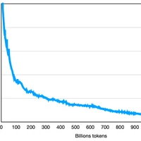

Interval Bound Interpolation for Few-shot Learning with Few Tasks
Few-shot learning aims to transfer the knowledge acquired from training on a diverse set of tasks to unseen tasks from the same task distribution with a limited amount of labeled data. The underlying requirement for effective few-shot generalization is to learn a good representation of the task manifold. This becomes more difficult when only a limited number of tasks are available for training. In such a few-task few-shot setting, it is beneficial to explicitly preserve the local neighborhoods from the task manifold and exploit this to generate artificial tasks for training. To this end, we introduce the notion of interval bounds from the provably robust training literature to few-shot learning. The interval bounds are used to characterize neighborhoods around the training tasks. These neighborhoods can then be preserved by minimizing the distance between a task and its respective bounds. We then use a novel strategy to artificially form new tasks for training by interpolating between the available tasks and their respective interval bounds. We apply our framework to both model-agnostic meta-learning as well as prototype-based metric-learning paradigms. The efficacy of our proposed approach is evident from the improved performance on several datasets from diverse domains compared to current methods.
Improving Tool Retrieval by Leveraging Large Language Models for Query Generation
Using tools by Large Language Models (LLMs) is a promising avenue to extend their reach beyond language or conversational settings. The number of tools can scale to thousands as they enable accessing sensory information, fetching updated factual knowledge, or taking actions in the real world. In such settings, in-context learning by providing a short list of relevant tools in the prompt is a viable approach. To retrieve relevant tools, various approaches have been suggested, ranging from simple frequency-based matching to dense embedding-based semantic retrieval. However, such approaches lack the contextual and common-sense understanding required to retrieve the right tools for complex user requests. Rather than increasing the complexity of the retrieval component itself, we propose leveraging LLM understanding to generate a retrieval query. Then, the generated query is embedded and used to find the most relevant tools via a nearest-neighbor search. We investigate three approaches for query generation: zero-shot prompting, supervised fine-tuning on tool descriptions, and alignment learning by iteratively optimizing a reward metric measuring retrieval performance. By conducting extensive experiments on a dataset covering complex and multi-tool scenarios, we show that leveraging LLMs for query generation improves the retrieval for in-domain (seen tools) and out-of-domain (unseen tools) settings.
Sufficient Context: A New Lens on Retrieval Augmented Generation Systems
Augmenting LLMs with context leads to improved performance across many applications. Despite much research on Retrieval Augmented Generation (RAG) systems, an open question is whether errors arise because LLMs fail to utilize the context from retrieval or the context itself is insufficient to answer the query. To shed light on this, we develop a new notion of sufficient context, along with a way to classify instances that have enough information to answer the query. We then use sufficient context to analyze several models and datasets. By stratifying errors based on context sufficiency, we find that proprietary LLMs (Gemini, GPT, Claude) excel at answering queries when the context is sufficient, but often output incorrect answers instead of abstaining when the context is not. On the other hand, open-source LLMs (Llama, Mistral, Gemma) hallucinate or abstain often, even with sufficient context. We further categorize cases when the context is useful, and improves accuracy, even though it does not fully answer the query and the model errs without the context. Building on our findings, we explore ways to reduce hallucinations in RAG systems, including a new selective generation method that leverages sufficient context information for guided abstention. Our method improves the fraction of correct answers among times where the model responds by 2-10% for Gemini, GPT, and Gemma.

Multimodal Needle in a Haystack: Benchmarking Long-Context Capability of Multimodal Large Language Models
Multimodal Large Language Models (MLLMs) have shown significant promise in various applications, leading to broad interest from researchers and practitioners alike. However, a comprehensive evaluation of their long-context capabilities remains underexplored. To address these gaps, we introduce the MultiModal Needle-in-a-haystack (MMNeedle) benchmark, specifically designed to assess the long-context capabilities of MLLMs. Besides multi-image input, we employ image stitching to further increase the input context length, and develop a protocol to automatically generate labels for sub-image level retrieval. Essentially, MMNeedle evaluates MLLMs by stress-testing their capability to locate a target sub-image (needle) within a set of images (haystack) based on textual instructions and descriptions of image contents. This setup necessitates an advanced understanding of extensive visual contexts and effective information retrieval within long-context image inputs. With this benchmark, we evaluate state-of-the-art MLLMs, encompassing both API-based and open-source models. The findings reveal that GPT-4o consistently surpasses other models in long-context scenarios, but suffers from hallucination problems in negative samples, i.e., when needles are not in the haystacks. Our comprehensive long-context evaluation of MLLMs also sheds lights on the considerable performance gap between API-based and open-source models. All the code, data, and instructions required to reproduce the main results are available at https://github.com/Wang-ML-Lab/multimodal-needle-in-a-haystack.


SAT: Spatial Aptitude Training for Multimodal Language Models
Spatial perception is a fundamental component of intelligence. While many studies highlight that large multimodal language models (MLMs) struggle to reason about space, they only test for static spatial reasoning, such as categorizing the relative positions of objects. Meanwhile, real-world deployment requires dynamic capabilities like perspective-taking and egocentric action recognition. As a roadmap to improving spatial intelligence, we introduce SAT, Spatial Aptitude Training, which goes beyond static relative object position questions to the more dynamic tasks. SAT contains 218K question-answer pairs for 22K synthetic scenes across a training and testing set. Generated using a photo-realistic physics engine, our dataset can be arbitrarily scaled and easily extended to new actions, scenes, and 3D assets. We find that even MLMs that perform relatively well on static questions struggle to accurately answer dynamic spatial questions. Further, we show that SAT instruction-tuning data improves not only dynamic spatial reasoning on SAT, but also zero-shot performance on existing real-image spatial benchmarks: 23% on CVBench, 8% on the harder BLINK benchmark, and 18% on VSR. When instruction-tuned on SAT, our 13B model matches larger proprietary MLMs like GPT4-V and Gemini-3-1.0 in spatial reasoning. Our data/code is available at http://arijitray1993.github.io/SAT/ .

FAR: Flexible, Accurate and Robust 6DoF Relative Camera Pose Estimation
Estimating relative camera poses between images has been a central problem in computer vision. Methods that find correspondences and solve for the fundamental matrix offer high precision in most cases. Conversely, methods predicting pose directly using neural networks are more robust to limited overlap and can infer absolute translation scale, but at the expense of reduced precision. We show how to combine the best of both methods; our approach yields results that are both precise and robust, while also accurately inferring translation scales. At the heart of our model lies a Transformer that (1) learns to balance between solved and learned pose estimations, and (2) provides a prior to guide a solver. A comprehensive analysis supports our design choices and demonstrates that our method adapts flexibly to various feature extractors and correspondence estimators, showing state-of-the-art performance in 6DoF pose estimation on Matterport3D, InteriorNet, StreetLearn, and Map-free Relocalization.


Coarse-to-Fine: Learning Compact Discriminative Representation for Single-Stage Image Retrieval
Image retrieval targets to find images from a database that are visually similar to the query image. Two-stage methods following retrieve-and-rerank paradigm have achieved excellent performance, but their separate local and global modules are inefficient to real-world applications. To better trade-off retrieval efficiency and accuracy, some approaches fuse global and local feature into a joint representation to perform single-stage image retrieval. However, they are still challenging due to various situations to tackle, e.g., background, occlusion and viewpoint. In this work, we design a Coarse-to-Fine framework to learn Compact Discriminative representation (CFCD) for end-to-end single-stage image retrieval-requiring only image-level labels. Specifically, we first design a novel adaptive softmax-based loss which dynamically tunes its scale and margin within each mini-batch and increases them progressively to strengthen supervision during training and intra-class compactness. Furthermore, we propose a mechanism which attentively selects prominent local descriptors and infuse fine-grained semantic relations into the global representation by a hard negative sampling strategy to optimize inter-class distinctiveness at a global scale. Extensive experimental results have demonstrated the effectiveness of our method, which achieves state-of-the-art single-stage image retrieval performance on benchmarks such as Revisited Oxford and Revisited Paris. Code is available at https://github.com/bassyess/CFCD.

NoLiMa: Long-Context Evaluation Beyond Literal Matching
Recent large language models (LLMs) support long contexts ranging from 128K to 1M tokens. A popular method for evaluating these capabilities is the needle-in-a-haystack (NIAH) test, which involves retrieving a "needle" (relevant information) from a "haystack" (long irrelevant context). Extensions of this approach include increasing distractors, fact chaining, and in-context reasoning. However, in these benchmarks, models can exploit existing literal matches between the needle and haystack to simplify the task. To address this, we introduce NoLiMa, a benchmark extending NIAH with a carefully designed needle set, where questions and needles have minimal lexical overlap, requiring models to infer latent associations to locate the needle within the haystack. We evaluate 12 popular LLMs that claim to support contexts of at least 128K tokens. While they perform well in short contexts (<1K), performance degrades significantly as context length increases. At 32K, for instance, 10 models drop below 50% of their strong short-length baselines. Even GPT-4o, one of the top-performing exceptions, experiences a reduction from an almost-perfect baseline of 99.3% to 69.7%. Our analysis suggests these declines stem from the increased difficulty the attention mechanism faces in longer contexts when literal matches are absent, making it harder to retrieve relevant information.


Towards Semantic Segmentation of Urban-Scale 3D Point Clouds: A Dataset, Benchmarks and Challenges
An essential prerequisite for unleashing the potential of supervised deep learning algorithms in the area of 3D scene understanding is the availability of large-scale and richly annotated datasets. However, publicly available datasets are either in relative small spatial scales or have limited semantic annotations due to the expensive cost of data acquisition and data annotation, which severely limits the development of fine-grained semantic understanding in the context of 3D point clouds. In this paper, we present an urban-scale photogrammetric point cloud dataset with nearly three billion richly annotated points, which is three times the number of labeled points than the existing largest photogrammetric point cloud dataset. Our dataset consists of large areas from three UK cities, covering about 7.6 km^2 of the city landscape. In the dataset, each 3D point is labeled as one of 13 semantic classes. We extensively evaluate the performance of state-of-the-art algorithms on our dataset and provide a comprehensive analysis of the results. In particular, we identify several key challenges towards urban-scale point cloud understanding. The dataset is available at https://github.com/QingyongHu/SensatUrban.
Cross Modal Retrieval with Querybank Normalisation
Profiting from large-scale training datasets, advances in neural architecture design and efficient inference, joint embeddings have become the dominant approach for tackling cross-modal retrieval. In this work we first show that, despite their effectiveness, state-of-the-art joint embeddings suffer significantly from the longstanding "hubness problem" in which a small number of gallery embeddings form the nearest neighbours of many queries. Drawing inspiration from the NLP literature, we formulate a simple but effective framework called Querybank Normalisation (QB-Norm) that re-normalises query similarities to account for hubs in the embedding space. QB-Norm improves retrieval performance without requiring retraining. Differently from prior work, we show that QB-Norm works effectively without concurrent access to any test set queries. Within the QB-Norm framework, we also propose a novel similarity normalisation method, the Dynamic Inverted Softmax, that is significantly more robust than existing approaches. We showcase QB-Norm across a range of cross modal retrieval models and benchmarks where it consistently enhances strong baselines beyond the state of the art. Code is available at https://vladbogo.github.io/QB-Norm/.


ST-VLM: Kinematic Instruction Tuning for Spatio-Temporal Reasoning in Vision-Language Models
Spatio-temporal reasoning is essential in understanding real-world environments in various fields, eg, autonomous driving and sports analytics. Recent advances have improved the spatial reasoning ability of Vision-Language Models (VLMs) by introducing large-scale data, but these models still struggle to analyze kinematic elements like traveled distance and speed of moving objects. To bridge this gap, we construct a spatio-temporal reasoning dataset and benchmark involving kinematic instruction tuning, referred to as STKit and STKit-Bench. They consist of real-world videos with 3D annotations, detailing object motion dynamics: traveled distance, speed, movement direction, inter-object distance comparisons, and relative movement direction. To further scale such data construction to videos without 3D labels, we propose an automatic pipeline to generate pseudo-labels using 4D reconstruction in real-world scale. With our kinematic instruction tuning data for spatio-temporal reasoning, we present ST-VLM, a VLM enhanced for spatio-temporal reasoning, which exhibits outstanding performance on STKit-Bench. Furthermore, we show that ST-VLM generalizes robustly across diverse domains and tasks, outperforming baselines on other spatio-temporal benchmarks (eg, ActivityNet, TVQA+). Finally, by integrating learned spatio-temporal reasoning with existing abilities, ST-VLM enables complex multi-step reasoning. Project page: https://ikodoh.github.io/ST-VLM.

PIFuHD: Multi-Level Pixel-Aligned Implicit Function for High-Resolution 3D Human Digitization
Recent advances in image-based 3D human shape estimation have been driven by the significant improvement in representation power afforded by deep neural networks. Although current approaches have demonstrated the potential in real world settings, they still fail to produce reconstructions with the level of detail often present in the input images. We argue that this limitation stems primarily form two conflicting requirements; accurate predictions require large context, but precise predictions require high resolution. Due to memory limitations in current hardware, previous approaches tend to take low resolution images as input to cover large spatial context, and produce less precise (or low resolution) 3D estimates as a result. We address this limitation by formulating a multi-level architecture that is end-to-end trainable. A coarse level observes the whole image at lower resolution and focuses on holistic reasoning. This provides context to an fine level which estimates highly detailed geometry by observing higher-resolution images. We demonstrate that our approach significantly outperforms existing state-of-the-art techniques on single image human shape reconstruction by fully leveraging 1k-resolution input images.


Geolocation Predicting of Tweets Using BERT-Based Models
This research is aimed to solve the tweet/user geolocation prediction task and provide a flexible methodology for the geotagging of textual big data. The suggested approach implements neural networks for natural language processing (NLP) to estimate the location as coordinate pairs (longitude, latitude) and two-dimensional Gaussian Mixture Models (GMMs). The scope of proposed models has been finetuned on a Twitter dataset using pretrained Bidirectional Encoder Representations from Transformers (BERT) as base models. Performance metrics show a median error of fewer than 30 km on a worldwide-level, and fewer than 15 km on the US-level datasets for the models trained and evaluated on text features of tweets' content and metadata context.
SetCSE: Set Operations using Contrastive Learning of Sentence Embeddings
Taking inspiration from Set Theory, we introduce SetCSE, an innovative information retrieval framework. SetCSE employs sets to represent complex semantics and incorporates well-defined operations for structured information querying under the provided context. Within this framework, we introduce an inter-set contrastive learning objective to enhance comprehension of sentence embedding models concerning the given semantics. Furthermore, we present a suite of operations, including SetCSE intersection, difference, and operation series, that leverage sentence embeddings of the enhanced model for complex sentence retrieval tasks. Throughout this paper, we demonstrate that SetCSE adheres to the conventions of human language expressions regarding compounded semantics, provides a significant enhancement in the discriminatory capability of underlying sentence embedding models, and enables numerous information retrieval tasks involving convoluted and intricate prompts which cannot be achieved using existing querying methods.

Detection, Tracking, and Counting Meets Drones in Crowds: A Benchmark
To promote the developments of object detection, tracking and counting algorithms in drone-captured videos, we construct a benchmark with a new drone-captured largescale dataset, named as DroneCrowd, formed by 112 video clips with 33,600 HD frames in various scenarios. Notably, we annotate 20,800 people trajectories with 4.8 million heads and several video-level attributes. Meanwhile, we design the Space-Time Neighbor-Aware Network (STNNet) as a strong baseline to solve object detection, tracking and counting jointly in dense crowds. STNNet is formed by the feature extraction module, followed by the density map estimation heads, and localization and association subnets. To exploit the context information of neighboring objects, we design the neighboring context loss to guide the association subnet training, which enforces consistent relative position of nearby objects in temporal domain. Extensive experiments on our DroneCrowd dataset demonstrate that STNNet performs favorably against the state-of-the-arts.

Density-invariant Features for Distant Point Cloud Registration
Registration of distant outdoor LiDAR point clouds is crucial to extending the 3D vision of collaborative autonomous vehicles, and yet is challenging due to small overlapping area and a huge disparity between observed point densities. In this paper, we propose Group-wise Contrastive Learning (GCL) scheme to extract density-invariant geometric features to register distant outdoor LiDAR point clouds. We mark through theoretical analysis and experiments that, contrastive positives should be independent and identically distributed (i.i.d.), in order to train densityinvariant feature extractors. We propose upon the conclusion a simple yet effective training scheme to force the feature of multiple point clouds in the same spatial location (referred to as positive groups) to be similar, which naturally avoids the sampling bias introduced by a pair of point clouds to conform with the i.i.d. principle. The resulting fully-convolutional feature extractor is more powerful and density-invariant than state-of-the-art methods, improving the registration recall of distant scenarios on KITTI and nuScenes benchmarks by 40.9% and 26.9%, respectively. Code is available at https://github.com/liuQuan98/GCL.
Lookback Lens: Detecting and Mitigating Contextual Hallucinations in Large Language Models Using Only Attention Maps
When asked to summarize articles or answer questions given a passage, large language models (LLMs) can hallucinate details and respond with unsubstantiated answers that are inaccurate with respect to the input context. This paper describes a simple approach for detecting such contextual hallucinations. We hypothesize that contextual hallucinations are related to the extent to which an LLM attends to information in the provided context versus its own generations. Based on this intuition, we propose a simple hallucination detection model whose input features are given by the ratio of attention weights on the context versus newly generated tokens (for each attention head). We find that a linear classifier based on these lookback ratio features is as effective as a richer detector that utilizes the entire hidden states of an LLM or a text-based entailment model. The lookback ratio-based detector -- Lookback Lens -- is found to transfer across tasks and even models, allowing a detector that is trained on a 7B model to be applied (without retraining) to a larger 13B model. We further apply this detector to mitigate contextual hallucinations, and find that a simple classifier-guided decoding approach is able to reduce the amount of hallucination, for example by 9.6% in the XSum summarization task.


Collaborative Metric Learning Recommendation System: Application to Theatrical Movie Releases
Product recommendation systems are important for major movie studios during the movie greenlight process and as part of machine learning personalization pipelines. Collaborative Filtering (CF) models have proved to be effective at powering recommender systems for online streaming services with explicit customer feedback data. CF models do not perform well in scenarios in which feedback data is not available, in cold start situations like new product launches, and situations with markedly different customer tiers (e.g., high frequency customers vs. casual customers). Generative natural language models that create useful theme-based representations of an underlying corpus of documents can be used to represent new product descriptions, like new movie plots. When combined with CF, they have shown to increase the performance in cold start situations. Outside of those cases though in which explicit customer feedback is available, recommender engines must rely on binary purchase data, which materially degrades performance. Fortunately, purchase data can be combined with product descriptions to generate meaningful representations of products and customer trajectories in a convenient product space in which proximity represents similarity. Learning to measure the distance between points in this space can be accomplished with a deep neural network that trains on customer histories and on dense vectorizations of product descriptions. We developed a system based on Collaborative (Deep) Metric Learning (CML) to predict the purchase probabilities of new theatrical releases. We trained and evaluated the model using a large dataset of customer histories, and tested the model for a set of movies that were released outside of the training window. Initial experiments show gains relative to models that do not train on collaborative preferences.
Decomposing Complex Queries for Tip-of-the-tongue Retrieval
When re-finding items, users who forget or are uncertain about identifying details often rely on creative strategies for expressing their information needs -- complex queries that describe content elements (e.g., book characters or events), information beyond the document text (e.g., descriptions of book covers), or personal context (e.g., when they read a book). This retrieval setting, called tip of the tongue (TOT), is especially challenging for models heavily reliant on lexical and semantic overlap between query and document text. In this work, we introduce a simple yet effective framework for handling such complex queries by decomposing the query into individual clues, routing those as sub-queries to specialized retrievers, and ensembling the results. This approach allows us to take advantage of off-the-shelf retrievers (e.g., CLIP for retrieving images of book covers) or incorporate retriever-specific logic (e.g., date constraints). We show that our framework incorportating query decompositions into retrievers can improve gold book recall up to 7% relative again for Recall@5 on a new collection of 14,441 real-world query-book pairs from an online community for resolving TOT inquiries.
Lightweight In-Context Tuning for Multimodal Unified Models
In-context learning (ICL) involves reasoning from given contextual examples. As more modalities comes, this procedure is becoming more challenging as the interleaved input modalities convolutes the understanding process. This is exemplified by the observation that multimodal models often struggle to effectively extrapolate from contextual examples to perform ICL. To address these challenges, we introduce MultiModal In-conteXt Tuning (M^2IXT), a lightweight module to enhance the ICL capabilities of multimodal unified models. The proposed M^2IXT module perceives an expandable context window to incorporate various labeled examples of multiple modalities (e.g., text, image, and coordinates). It can be prepended to various multimodal unified models (e.g., OFA, Unival, LLaVA) of different architectures and trained via a mixed-tasks strategy to enable rapid few-shot adaption on multiple tasks and datasets. When tuned on as little as 50K multimodal data, M^2IXT can boost the few-shot ICL performance significantly (e.g., 18\% relative increase for OFA), and obtained state-of-the-art results across an array of tasks including visual question answering, image captioning, visual grounding, and visual entailment, while being considerably small in terms of model parameters (e.g., sim20times smaller than Flamingo or MMICL), highlighting the flexibility and effectiveness of M^2IXT as a multimodal in-context learner.

Knowledge Graph Embedding: An Overview
Many mathematical models have been leveraged to design embeddings for representing Knowledge Graph (KG) entities and relations for link prediction and many downstream tasks. These mathematically-inspired models are not only highly scalable for inference in large KGs, but also have many explainable advantages in modeling different relation patterns that can be validated through both formal proofs and empirical results. In this paper, we make a comprehensive overview of the current state of research in KG completion. In particular, we focus on two main branches of KG embedding (KGE) design: 1) distance-based methods and 2) semantic matching-based methods. We discover the connections between recently proposed models and present an underlying trend that might help researchers invent novel and more effective models. Next, we delve into CompoundE and CompoundE3D, which draw inspiration from 2D and 3D affine operations, respectively. They encompass a broad spectrum of techniques including distance-based and semantic-based methods. We will also discuss an emerging approach for KG completion which leverages pre-trained language models (PLMs) and textual descriptions of entities and relations and offer insights into the integration of KGE embedding methods with PLMs for KG completion.

Needle Threading: Can LLMs Follow Threads through Near-Million-Scale Haystacks?
As the context limits of Large Language Models (LLMs) increase, the range of possible applications and downstream functions broadens. In many real-world tasks, decisions depend on details scattered across collections of often disparate documents containing mostly irrelevant information. Long-context LLMs appear well-suited to this form of complex information retrieval and reasoning, which has traditionally proven costly and time-consuming. However, although the development of longer context models has seen rapid gains in recent years, our understanding of how effectively LLMs use their context has not kept pace. To address this, we conduct a set of retrieval experiments designed to evaluate the capabilities of 17 leading LLMs, such as their ability to follow threads of information through the context window. Strikingly, we find that many models are remarkably threadsafe: capable of simultaneously following multiple threads without significant loss in performance. Still, for many models, we find the effective context limit is significantly shorter than the supported context length, with accuracy decreasing as the context window grows. Our study also highlights the important point that token counts from different tokenizers should not be directly compared -- they often correspond to substantially different numbers of written characters. We release our code and long-context experimental data.

Learning to Reconstruct and Segment 3D Objects
To endow machines with the ability to perceive the real-world in a three dimensional representation as we do as humans is a fundamental and long-standing topic in Artificial Intelligence. Given different types of visual inputs such as images or point clouds acquired by 2D/3D sensors, one important goal is to understand the geometric structure and semantics of the 3D environment. Traditional approaches usually leverage hand-crafted features to estimate the shape and semantics of objects or scenes. However, they are difficult to generalize to novel objects and scenarios, and struggle to overcome critical issues caused by visual occlusions. By contrast, we aim to understand scenes and the objects within them by learning general and robust representations using deep neural networks, trained on large-scale real-world 3D data. To achieve these aims, this thesis makes three core contributions from object-level 3D shape estimation from single or multiple views to scene-level semantic understanding.
LLMGeo: Benchmarking Large Language Models on Image Geolocation In-the-wild
Image geolocation is a critical task in various image-understanding applications. However, existing methods often fail when analyzing challenging, in-the-wild images. Inspired by the exceptional background knowledge of multimodal language models, we systematically evaluate their geolocation capabilities using a novel image dataset and a comprehensive evaluation framework. We first collect images from various countries via Google Street View. Then, we conduct training-free and training-based evaluations on closed-source and open-source multi-modal language models. we conduct both training-free and training-based evaluations on closed-source and open-source multimodal language models. Our findings indicate that closed-source models demonstrate superior geolocation abilities, while open-source models can achieve comparable performance through fine-tuning.

In-Context Learning for Text Classification with Many Labels
In-context learning (ICL) using large language models for tasks with many labels is challenging due to the limited context window, which makes it difficult to fit a sufficient number of examples in the prompt. In this paper, we use a pre-trained dense retrieval model to bypass this limitation, giving the model only a partial view of the full label space for each inference call. Testing with recent open-source LLMs (OPT, LLaMA), we set new state of the art performance in few-shot settings for three common intent classification datasets, with no finetuning. We also surpass fine-tuned performance on fine-grained sentiment classification in certain cases. We analyze the performance across number of in-context examples and different model scales, showing that larger models are necessary to effectively and consistently make use of larger context lengths for ICL. By running several ablations, we analyze the model's use of: a) the similarity of the in-context examples to the current input, b) the semantic content of the class names, and c) the correct correspondence between examples and labels. We demonstrate that all three are needed to varying degrees depending on the domain, contrary to certain recent works.
Charting New Territories: Exploring the Geographic and Geospatial Capabilities of Multimodal LLMs
Multimodal large language models (MLLMs) have shown remarkable capabilities across a broad range of tasks but their knowledge and abilities in the geographic and geospatial domains are yet to be explored, despite potential wide-ranging benefits to navigation, environmental research, urban development, and disaster response. We conduct a series of experiments exploring various vision capabilities of MLLMs within these domains, particularly focusing on the frontier model GPT-4V, and benchmark its performance against open-source counterparts. Our methodology involves challenging these models with a small-scale geographic benchmark consisting of a suite of visual tasks, testing their abilities across a spectrum of complexity. The analysis uncovers not only where such models excel, including instances where they outperform humans, but also where they falter, providing a balanced view of their capabilities in the geographic domain. To enable the comparison and evaluation of future models, our benchmark will be publicly released.
Localizing Moments in Video with Natural Language
We consider retrieving a specific temporal segment, or moment, from a video given a natural language text description. Methods designed to retrieve whole video clips with natural language determine what occurs in a video but not when. To address this issue, we propose the Moment Context Network (MCN) which effectively localizes natural language queries in videos by integrating local and global video features over time. A key obstacle to training our MCN model is that current video datasets do not include pairs of localized video segments and referring expressions, or text descriptions which uniquely identify a corresponding moment. Therefore, we collect the Distinct Describable Moments (DiDeMo) dataset which consists of over 10,000 unedited, personal videos in diverse visual settings with pairs of localized video segments and referring expressions. We demonstrate that MCN outperforms several baseline methods and believe that our initial results together with the release of DiDeMo will inspire further research on localizing video moments with natural language.

Long Context vs. RAG for LLMs: An Evaluation and Revisits
Extending context windows (i.e., Long Context, LC) and using retrievers to selectively access relevant information (i.e., Retrieval-Augmented Generation, RAG) are the two main strategies to enable LLMs to incorporate extremely long external contexts. This paper revisits recent studies on this topic, highlighting their key insights and discrepancies. We then provide a more comprehensive evaluation by filtering out questions answerable without external context, identifying the most effective retrieval methods, and expanding the datasets. We show that LC generally outperforms RAG in question-answering benchmarks, especially for Wikipedia-based questions. Summarization-based retrieval performs comparably to LC, while chunk-based retrieval lags behind. However, RAG has advantages in dialogue-based and general question queries. These insights underscore the trade-offs between RAG and LC strategies, offering guidance for future optimization of LLMs with external knowledge sources. We also provide an in-depth discussion on this topic, highlighting the overlooked importance of context relevance in existing studies.
Latent Compass: Creation by Navigation
In Marius von Senden's Space and Sight, a newly sighted blind patient describes the experience of a corner as lemon-like, because corners "prick" sight like lemons prick the tongue. Prickliness, here, is a dimension in the feature space of sensory experience, an effect of the perceived on the perceiver that arises where the two interact. In the account of the newly sighted, an effect familiar from one interaction translates to a novel context. Perception serves as the vehicle for generalization, in that an effect shared across different experiences produces a concrete abstraction grounded in those experiences. Cezanne and the post-impressionists, fluent in the language of experience translation, realized that the way to paint a concrete form that best reflected reality was to paint not what they saw, but what it was like to see. We envision a future of creation using AI where what it is like to see is replicable, transferrable, manipulable - part of the artist's palette that is both grounded in a particular context, and generalizable beyond it. An active line of research maps human-interpretable features onto directions in GAN latent space. Supervised and self-supervised approaches that search for anticipated directions or use off-the-shelf classifiers to drive image manipulation in embedding space are limited in the variety of features they can uncover. Unsupervised approaches that discover useful new directions show that the space of perceptually meaningful directions is nowhere close to being fully mapped. As this space is broad and full of creative potential, we want tools for direction discovery that capture the richness and generalizability of human perception. Our approach puts creators in the discovery loop during real-time tool use, in order to identify directions that are perceptually meaningful to them, and generate interpretable image translations along those directions.


HaLo-NeRF: Learning Geometry-Guided Semantics for Exploring Unconstrained Photo Collections
Internet image collections containing photos captured by crowds of photographers show promise for enabling digital exploration of large-scale tourist landmarks. However, prior works focus primarily on geometric reconstruction and visualization, neglecting the key role of language in providing a semantic interface for navigation and fine-grained understanding. In constrained 3D domains, recent methods have leveraged vision-and-language models as a strong prior of 2D visual semantics. While these models display an excellent understanding of broad visual semantics, they struggle with unconstrained photo collections depicting such tourist landmarks, as they lack expert knowledge of the architectural domain. In this work, we present a localization system that connects neural representations of scenes depicting large-scale landmarks with text describing a semantic region within the scene, by harnessing the power of SOTA vision-and-language models with adaptations for understanding landmark scene semantics. To bolster such models with fine-grained knowledge, we leverage large-scale Internet data containing images of similar landmarks along with weakly-related textual information. Our approach is built upon the premise that images physically grounded in space can provide a powerful supervision signal for localizing new concepts, whose semantics may be unlocked from Internet textual metadata with large language models. We use correspondences between views of scenes to bootstrap spatial understanding of these semantics, providing guidance for 3D-compatible segmentation that ultimately lifts to a volumetric scene representation. Our results show that HaLo-NeRF can accurately localize a variety of semantic concepts related to architectural landmarks, surpassing the results of other 3D models as well as strong 2D segmentation baselines. Our project page is at https://tau-vailab.github.io/HaLo-NeRF/.


Diversity Aware Relevance Learning for Argument Search
In this work, we focus on the problem of retrieving relevant arguments for a query claim covering diverse aspects. State-of-the-art methods rely on explicit mappings between claims and premises, and thus are unable to utilize large available collections of premises without laborious and costly manual annotation. Their diversity approach relies on removing duplicates via clustering which does not directly ensure that the selected premises cover all aspects. This work introduces a new multi-step approach for the argument retrieval problem. Rather than relying on ground-truth assignments, our approach employs a machine learning model to capture semantic relationships between arguments. Beyond that, it aims to cover diverse facets of the query, instead of trying to identify duplicates explicitly. Our empirical evaluation demonstrates that our approach leads to a significant improvement in the argument retrieval task even though it requires less data.

Weakly-Supervised Conditional Embedding for Referred Visual Search
This paper presents a new approach to image similarity search in the context of fashion, a domain with inherent ambiguity due to the multiple ways in which images can be considered similar. We introduce the concept of Referred Visual Search (RVS), where users provide additional information to define the desired similarity. We present a new dataset, LAION-RVS-Fashion, consisting of 272K fashion products with 842K images extracted from LAION, designed explicitly for this task. We then propose an innovative method for learning conditional embeddings using weakly-supervised training, achieving a 6% increase in Recall at one (R@1) against a gallery with 2M distractors, compared to classical approaches based on explicit attention and filtering. The proposed method demonstrates robustness, maintaining similar R@1 when dealing with 2.5 times as many distractors as the baseline methods. We believe this is a step forward in the emerging field of Referred Visual Search both in terms of accessible data and approach. Code, data and models are available at https://www.github.com/Simon-Lepage/CondViT-LRVSF .


Dual-View Visual Contextualization for Web Navigation
Automatic web navigation aims to build a web agent that can follow language instructions to execute complex and diverse tasks on real-world websites. Existing work primarily takes HTML documents as input, which define the contents and action spaces (i.e., actionable elements and operations) of webpages. Nevertheless, HTML documents may not provide a clear task-related context for each element, making it hard to select the right (sequence of) actions. In this paper, we propose to contextualize HTML elements through their "dual views" in webpage screenshots: each HTML element has its corresponding bounding box and visual content in the screenshot. We build upon the insight -- web developers tend to arrange task-related elements nearby on webpages to enhance user experiences -- and propose to contextualize each element with its neighbor elements, using both textual and visual features. The resulting representations of HTML elements are more informative for the agent to take action. We validate our method on the recently released Mind2Web dataset, which features diverse navigation domains and tasks on real-world websites. Our method consistently outperforms the baseline in all the scenarios, including cross-task, cross-website, and cross-domain ones.


Hyper-multi-step: The Truth Behind Difficult Long-context Tasks
Long-context language models (LCLM), characterized by their extensive context window, is becoming increasingly popular. Meanwhile, many long-context benchmarks present challenging tasks that even the most advanced LCLMs struggle to complete. However, the underlying sources of various challenging long-context tasks have seldom been studied. To bridge this gap, we conduct experiments to indicate their difficulty stems primarily from two basic issues: "multi-matching retrieval," which requires the simultaneous retrieval of multiple items, and "logic-based retrieval," which necessitates logical judgment within retrieval criteria. These two problems, while seemingly straightforward, actually exceed the capabilities of LCLMs because they are proven to be hyper-multi-step (demanding numerous steps to solve) in nature. This finding could explain why LLMs struggle with more advanced long-context tasks, providing a more accurate perspective for rethinking solutions for them.

Granular Privacy Control for Geolocation with Vision Language Models
Vision Language Models (VLMs) are rapidly advancing in their capability to answer information-seeking questions. As these models are widely deployed in consumer applications, they could lead to new privacy risks due to emergent abilities to identify people in photos, geolocate images, etc. As we demonstrate, somewhat surprisingly, current open-source and proprietary VLMs are very capable image geolocators, making widespread geolocation with VLMs an immediate privacy risk, rather than merely a theoretical future concern. As a first step to address this challenge, we develop a new benchmark, GPTGeoChat, to test the ability of VLMs to moderate geolocation dialogues with users. We collect a set of 1,000 image geolocation conversations between in-house annotators and GPT-4v, which are annotated with the granularity of location information revealed at each turn. Using this new dataset, we evaluate the ability of various VLMs to moderate GPT-4v geolocation conversations by determining when too much location information has been revealed. We find that custom fine-tuned models perform on par with prompted API-based models when identifying leaked location information at the country or city level; however, fine-tuning on supervised data appears to be needed to accurately moderate finer granularities, such as the name of a restaurant or building.


CUE-M: Contextual Understanding and Enhanced Search with Multimodal Large Language Model
The integration of Retrieval-Augmented Generation (RAG) with Multimodal Large Language Models (MLLMs) has revolutionized information retrieval and expanded the practical applications of AI. However, current systems struggle in accurately interpreting user intent, employing diverse retrieval strategies, and effectively filtering unintended or inappropriate responses, limiting their effectiveness. This paper introduces Contextual Understanding and Enhanced Search with MLLM (CUE-M), a novel multimodal search framework that addresses these challenges through a multi-stage pipeline comprising image context enrichment, intent refinement, contextual query generation, external API integration, and relevance-based filtering. CUE-M incorporates a robust filtering pipeline combining image-based, text-based, and multimodal classifiers, dynamically adapting to instance- and category-specific concern defined by organizational policies. Evaluations on a multimodal Q&A dataset and a public safety benchmark demonstrate that CUE-M outperforms baselines in accuracy, knowledge integration, and safety, advancing the capabilities of multimodal retrieval systems.
A Controlled Study on Long Context Extension and Generalization in LLMs
Broad textual understanding and in-context learning require language models that utilize full document contexts. Due to the implementation challenges associated with directly training long-context models, many methods have been proposed for extending models to handle long contexts. However, owing to differences in data and model classes, it has been challenging to compare these approaches, leading to uncertainty as to how to evaluate long-context performance and whether it differs from standard evaluation. We implement a controlled protocol for extension methods with a standardized evaluation, utilizing consistent base models and extension data. Our study yields several insights into long-context behavior. First, we reaffirm the critical role of perplexity as a general-purpose performance indicator even in longer-context tasks. Second, we find that current approximate attention methods systematically underperform across long-context tasks. Finally, we confirm that exact fine-tuning based methods are generally effective within the range of their extension, whereas extrapolation remains challenging. All codebases, models, and checkpoints will be made available open-source, promoting transparency and facilitating further research in this critical area of AI development.


Adaptive Contrastive Decoding in Retrieval-Augmented Generation for Handling Noisy Contexts
When using large language models (LLMs) in knowledge-intensive tasks, such as open-domain question answering, external context can bridge the gap between external knowledge and the LLMs' parametric knowledge. Recent research has been developed to amplify contextual knowledge over the parametric knowledge of LLMs with contrastive decoding approaches. While these approaches could yield truthful responses when relevant context is provided, they are prone to vulnerabilities when faced with noisy contexts. We extend the scope of previous studies to encompass noisy contexts and propose adaptive contrastive decoding (ACD) to leverage contextual influence effectively. ACD demonstrates improvements in open-domain question answering tasks compared to baselines, especially in robustness by remaining undistracted by noisy contexts in retrieval-augmented generation.

Probing the Role of Positional Information in Vision-Language Models
In most Vision-Language models (VL), the understanding of the image structure is enabled by injecting the position information (PI) about objects in the image. In our case study of LXMERT, a state-of-the-art VL model, we probe the use of the PI in the representation and study its effect on Visual Question Answering. We show that the model is not capable of leveraging the PI for the image-text matching task on a challenge set where only position differs. Yet, our experiments with probing confirm that the PI is indeed present in the representation. We introduce two strategies to tackle this: (i) Positional Information Pre-training and (ii) Contrastive Learning on PI using Cross-Modality Matching. Doing so, the model can correctly classify if images with detailed PI statements match. Additionally to the 2D information from bounding boxes, we introduce the object's depth as new feature for a better object localization in the space. Even though we were able to improve the model properties as defined by our probes, it only has a negligible effect on the downstream performance. Our results thus highlight an important issue of multimodal modeling: the mere presence of information detectable by a probing classifier is not a guarantee that the information is available in a cross-modal setup.
How do Language Models Bind Entities in Context?
To correctly use in-context information, language models (LMs) must bind entities to their attributes. For example, given a context describing a "green square" and a "blue circle", LMs must bind the shapes to their respective colors. We analyze LM representations and identify the binding ID mechanism: a general mechanism for solving the binding problem, which we observe in every sufficiently large model from the Pythia and LLaMA families. Using causal interventions, we show that LMs' internal activations represent binding information by attaching binding ID vectors to corresponding entities and attributes. We further show that binding ID vectors form a continuous subspace, in which distances between binding ID vectors reflect their discernability. Overall, our results uncover interpretable strategies in LMs for representing symbolic knowledge in-context, providing a step towards understanding general in-context reasoning in large-scale LMs.

Visual Features for Context-Aware Speech Recognition
Automatic transcriptions of consumer-generated multi-media content such as "Youtube" videos still exhibit high word error rates. Such data typically occupies a very broad domain, has been recorded in challenging conditions, with cheap hardware and a focus on the visual modality, and may have been post-processed or edited. In this paper, we extend our earlier work on adapting the acoustic model of a DNN-based speech recognition system to an RNN language model and show how both can be adapted to the objects and scenes that can be automatically detected in the video. We are working on a corpus of "how-to" videos from the web, and the idea is that an object that can be seen ("car"), or a scene that is being detected ("kitchen") can be used to condition both models on the "context" of the recording, thereby reducing perplexity and improving transcription. We achieve good improvements in both cases and compare and analyze the respective reductions in word error rate. We expect that our results can be used for any type of speech processing in which "context" information is available, for example in robotics, man-machine interaction, or when indexing large audio-visual archives, and should ultimately help to bring together the "video-to-text" and "speech-to-text" communities.

Focused Transformer: Contrastive Training for Context Scaling
Large language models have an exceptional capability to incorporate new information in a contextual manner. However, the full potential of such an approach is often restrained due to a limitation in the effective context length. One solution to this issue is to endow an attention layer with access to an external memory, which comprises of (key, value) pairs. Yet, as the number of documents increases, the proportion of relevant keys to irrelevant ones decreases, leading the model to focus more on the irrelevant keys. We identify a significant challenge, dubbed the distraction issue, where keys linked to different semantic values might overlap, making them hard to distinguish. To tackle this problem, we introduce the Focused Transformer (FoT), a technique that employs a training process inspired by contrastive learning. This novel approach enhances the structure of the (key, value) space, enabling an extension of the context length. Our method allows for fine-tuning pre-existing, large-scale models to lengthen their effective context. This is demonstrated by our fine-tuning of 3B and 7B OpenLLaMA checkpoints. The resulting models, which we name LongLLaMA, exhibit advancements in tasks requiring a long context. We further illustrate that our LongLLaMA models adeptly manage a 256 k context length for passkey retrieval.


Understanding Points of Correspondence between Sentences for Abstractive Summarization
Fusing sentences containing disparate content is a remarkable human ability that helps create informative and succinct summaries. Such a simple task for humans has remained challenging for modern abstractive summarizers, substantially restricting their applicability in real-world scenarios. In this paper, we present an investigation into fusing sentences drawn from a document by introducing the notion of points of correspondence, which are cohesive devices that tie any two sentences together into a coherent text. The types of points of correspondence are delineated by text cohesion theory, covering pronominal and nominal referencing, repetition and beyond. We create a dataset containing the documents, source and fusion sentences, and human annotations of points of correspondence between sentences. Our dataset bridges the gap between coreference resolution and summarization. It is publicly shared to serve as a basis for future work to measure the success of sentence fusion systems. (https://github.com/ucfnlp/points-of-correspondence)

MagicLens: Self-Supervised Image Retrieval with Open-Ended Instructions
Image retrieval, i.e., finding desired images given a reference image, inherently encompasses rich, multi-faceted search intents that are difficult to capture solely using image-based measures. Recent work leverages text instructions to allow users to more freely express their search intents. However, existing work primarily focuses on image pairs that are visually similar and/or can be characterized by a small set of pre-defined relations. The core thesis of this paper is that text instructions can enable retrieving images with richer relations beyond visual similarity. To show this, we introduce MagicLens, a series of self-supervised image retrieval models that support open-ended instructions. MagicLens is built on a key novel insight: image pairs that naturally occur on the same web pages contain a wide range of implicit relations (e.g., inside view of), and we can bring those implicit relations explicit by synthesizing instructions via large multimodal models (LMMs) and large language models (LLMs). Trained on 36.7M (query image, instruction, target image) triplets with rich semantic relations mined from the web, MagicLens achieves comparable or better results on eight benchmarks of various image retrieval tasks than prior state-of-the-art (SOTA) methods. Remarkably, it outperforms previous SOTA but with a 50X smaller model size on multiple benchmarks. Additional human analyses on a 1.4M-image unseen corpus further demonstrate the diversity of search intents supported by MagicLens.


Aspect-based Document Similarity for Research Papers
Traditional document similarity measures provide a coarse-grained distinction between similar and dissimilar documents. Typically, they do not consider in what aspects two documents are similar. This limits the granularity of applications like recommender systems that rely on document similarity. In this paper, we extend similarity with aspect information by performing a pairwise document classification task. We evaluate our aspect-based document similarity for research papers. Paper citations indicate the aspect-based similarity, i.e., the section title in which a citation occurs acts as a label for the pair of citing and cited paper. We apply a series of Transformer models such as RoBERTa, ELECTRA, XLNet, and BERT variations and compare them to an LSTM baseline. We perform our experiments on two newly constructed datasets of 172,073 research paper pairs from the ACL Anthology and CORD-19 corpus. Our results show SciBERT as the best performing system. A qualitative examination validates our quantitative results. Our findings motivate future research of aspect-based document similarity and the development of a recommender system based on the evaluated techniques. We make our datasets, code, and trained models publicly available.

PerLA: Perceptive 3D Language Assistant
Enabling Large Language Models (LLMs) to understand the 3D physical world is an emerging yet challenging research direction. Current strategies for processing point clouds typically downsample the scene or divide it into smaller parts for separate analysis. However, both approaches risk losing key local details or global contextual information. In this paper, we introduce PerLA, a 3D language assistant designed to be more perceptive to both details and context, making visual representations more informative for the LLM. PerLA captures high-resolution (local) details in parallel from different point cloud areas and integrates them with (global) context obtained from a lower-resolution whole point cloud. We present a novel algorithm that preserves point cloud locality through the Hilbert curve and effectively aggregates local-to-global information via cross-attention and a graph neural network. Lastly, we introduce a novel loss for local representation consensus to promote training stability. PerLA outperforms state-of-the-art 3D language assistants, with gains of up to +1.34 CiDEr on ScanQA for question answering, and +4.22 on ScanRefer and +3.88 on Nr3D for dense captioning.https://gfmei.github.io/PerLA/


Retrieving Multimodal Information for Augmented Generation: A Survey
In this survey, we review methods that retrieve multimodal knowledge to assist and augment generative models. This group of works focuses on retrieving grounding contexts from external sources, including images, codes, tables, graphs, and audio. As multimodal learning and generative AI have become more and more impactful, such retrieval augmentation offers a promising solution to important concerns such as factuality, reasoning, interpretability, and robustness. We provide an in-depth review of retrieval-augmented generation in different modalities and discuss potential future directions. As this is an emerging field, we continue to add new papers and methods.

ImageRef-VL: Enabling Contextual Image Referencing in Vision-Language Models
Vision-Language Models (VLMs) have demonstrated remarkable capabilities in understanding multimodal inputs and have been widely integrated into Retrieval-Augmented Generation (RAG) based conversational systems. While current VLM-powered chatbots can provide textual source references in their responses, they exhibit significant limitations in referencing contextually relevant images during conversations. In this paper, we introduce Contextual Image Reference -- the ability to appropriately reference relevant images from retrieval documents based on conversation context -- and systematically investigate VLMs' capability in this aspect. We conduct the first evaluation for contextual image referencing, comprising a dedicated testing dataset and evaluation metrics. Furthermore, we propose ImageRef-VL, a method that significantly enhances open-source VLMs' image referencing capabilities through instruction fine-tuning on a large-scale, manually curated multimodal conversation dataset. Experimental results demonstrate that ImageRef-VL not only outperforms proprietary models but also achieves an 88% performance improvement over state-of-the-art open-source VLMs in contextual image referencing tasks. Our code is available at https://github.com/bytedance/ImageRef-VL.
DelucionQA: Detecting Hallucinations in Domain-specific Question Answering
Hallucination is a well-known phenomenon in text generated by large language models (LLMs). The existence of hallucinatory responses is found in almost all application scenarios e.g., summarization, question-answering (QA) etc. For applications requiring high reliability (e.g., customer-facing assistants), the potential existence of hallucination in LLM-generated text is a critical problem. The amount of hallucination can be reduced by leveraging information retrieval to provide relevant background information to the LLM. However, LLMs can still generate hallucinatory content for various reasons (e.g., prioritizing its parametric knowledge over the context, failure to capture the relevant information from the context, etc.). Detecting hallucinations through automated methods is thus paramount. To facilitate research in this direction, we introduce a sophisticated dataset, DelucionQA, that captures hallucinations made by retrieval-augmented LLMs for a domain-specific QA task. Furthermore, we propose a set of hallucination detection methods to serve as baselines for future works from the research community. Analysis and case study are also provided to share valuable insights on hallucination phenomena in the target scenario.


Visual Spatial Description: Controlled Spatial-Oriented Image-to-Text Generation
Image-to-text tasks, such as open-ended image captioning and controllable image description, have received extensive attention for decades. Here, we further advance this line of work by presenting Visual Spatial Description (VSD), a new perspective for image-to-text toward spatial semantics. Given an image and two objects inside it, VSD aims to produce one description focusing on the spatial perspective between the two objects. Accordingly, we manually annotate a dataset to facilitate the investigation of the newly-introduced task and build several benchmark encoder-decoder models by using VL-BART and VL-T5 as backbones. In addition, we investigate pipeline and joint end-to-end architectures for incorporating visual spatial relationship classification (VSRC) information into our model. Finally, we conduct experiments on our benchmark dataset to evaluate all our models. Results show that our models are impressive, providing accurate and human-like spatial-oriented text descriptions. Meanwhile, VSRC has great potential for VSD, and the joint end-to-end architecture is the better choice for their integration. We make the dataset and codes public for research purposes.
Global Context Networks
The Non-Local Network (NLNet) presents a pioneering approach for capturing long-range dependencies within an image, via aggregating query-specific global context to each query position. However, through a rigorous empirical analysis, we have found that the global contexts modeled by the non-local network are almost the same for different query positions. In this paper, we take advantage of this finding to create a simplified network based on a query-independent formulation, which maintains the accuracy of NLNet but with significantly less computation. We further replace the one-layer transformation function of the non-local block by a two-layer bottleneck, which further reduces the parameter number considerably. The resulting network element, called the global context (GC) block, effectively models global context in a lightweight manner, allowing it to be applied at multiple layers of a backbone network to form a global context network (GCNet). Experiments show that GCNet generally outperforms NLNet on major benchmarks for various recognition tasks. The code and network configurations are available at https://github.com/xvjiarui/GCNet.
Around the World in 80 Timesteps: A Generative Approach to Global Visual Geolocation
Global visual geolocation predicts where an image was captured on Earth. Since images vary in how precisely they can be localized, this task inherently involves a significant degree of ambiguity. However, existing approaches are deterministic and overlook this aspect. In this paper, we aim to close the gap between traditional geolocalization and modern generative methods. We propose the first generative geolocation approach based on diffusion and Riemannian flow matching, where the denoising process operates directly on the Earth's surface. Our model achieves state-of-the-art performance on three visual geolocation benchmarks: OpenStreetView-5M, YFCC-100M, and iNat21. In addition, we introduce the task of probabilistic visual geolocation, where the model predicts a probability distribution over all possible locations instead of a single point. We introduce new metrics and baselines for this task, demonstrating the advantages of our diffusion-based approach. Codes and models will be made available.

Beyond LLaVA-HD: Diving into High-Resolution Large Multimodal Models
Seeing clearly with high resolution is a foundation of Large Multimodal Models (LMMs), which has been proven to be vital for visual perception and reasoning. Existing works usually employ a straightforward resolution upscaling method, where the image consists of global and local branches, with the latter being the sliced image patches but resized to the same resolution as the former. This means that higher resolution requires more local patches, resulting in exorbitant computational expenses, and meanwhile, the dominance of local image tokens may diminish the global context. In this paper, we dive into the problems and propose a new framework as well as an elaborate optimization strategy. Specifically, we extract contextual information from the global view using a mixture of adapters, based on the observation that different adapters excel at different tasks. With regard to local patches, learnable query embeddings are introduced to reduce image tokens, the most important tokens accounting for the user question will be further selected by a similarity-based selector. Our empirical results demonstrate a `less is more' pattern, where utilizing fewer but more informative local image tokens leads to improved performance. Besides, a significant challenge lies in the training strategy, as simultaneous end-to-end training of the global mining block and local compression block does not yield optimal results. We thus advocate for an alternating training way, ensuring balanced learning between global and local aspects. Finally, we also introduce a challenging dataset with high requirements for image detail, enhancing the training of the local compression layer. The proposed method, termed LMM with Sophisticated Tasks, Local image compression, and Mixture of global Experts (SliME), achieves leading performance across various benchmarks with only 2 million training data.

OmniDiff: A Comprehensive Benchmark for Fine-grained Image Difference Captioning
Image Difference Captioning (IDC) aims to generate natural language descriptions of subtle differences between image pairs, requiring both precise visual change localization and coherent semantic expression. Despite recent advancements, existing datasets often lack breadth and depth, limiting their applicability in complex and dynamic environments: (1) from a breadth perspective, current datasets are constrained to limited variations of objects in specific scenes, and (2) from a depth perspective, prior benchmarks often provide overly simplistic descriptions. To address these challenges, we introduce OmniDiff, a comprehensive dataset comprising 324 diverse scenarios-spanning real-world complex environments and 3D synthetic settings-with fine-grained human annotations averaging 60 words in length and covering 12 distinct change types. Building on this foundation, we propose M^3Diff, a MultiModal large language model enhanced by a plug-and-play Multi-scale Differential Perception (MDP) module. This module improves the model's ability to accurately identify and describe inter-image differences while maintaining the foundational model's generalization capabilities. With the addition of the OmniDiff dataset, M^3Diff achieves state-of-the-art performance across multiple benchmarks, including Spot-the-Diff, IEdit, CLEVR-Change, CLEVR-DC, and OmniDiff, demonstrating significant improvements in cross-scenario difference recognition accuracy compared to existing methods. The dataset, code, and models will be made publicly available to support further research.
SPair-71k: A Large-scale Benchmark for Semantic Correspondence
Establishing visual correspondences under large intra-class variations, which is often referred to as semantic correspondence or semantic matching, remains a challenging problem in computer vision. Despite its significance, however, most of the datasets for semantic correspondence are limited to a small amount of image pairs with similar viewpoints and scales. In this paper, we present a new large-scale benchmark dataset of semantically paired images, SPair-71k, which contains 70,958 image pairs with diverse variations in viewpoint and scale. Compared to previous datasets, it is significantly larger in number and contains more accurate and richer annotations. We believe this dataset will provide a reliable testbed to study the problem of semantic correspondence and will help to advance research in this area. We provide the results of recent methods on our new dataset as baselines for further research. Our benchmark is available online at http://cvlab.postech.ac.kr/research/SPair-71k/.
Internet-Augmented Dialogue Generation
The largest store of continually updating knowledge on our planet can be accessed via internet search. In this work we study giving access to this information to conversational agents. Large language models, even though they store an impressive amount of knowledge within their weights, are known to hallucinate facts when generating dialogue (Shuster et al., 2021); moreover, those facts are frozen in time at the point of model training. In contrast, we propose an approach that learns to generate an internet search query based on the context, and then conditions on the search results to finally generate a response, a method that can employ up-to-the-minute relevant information. We train and evaluate such models on a newly collected dataset of human-human conversations whereby one of the speakers is given access to internet search during knowledgedriven discussions in order to ground their responses. We find that search-query based access of the internet in conversation provides superior performance compared to existing approaches that either use no augmentation or FAISS-based retrieval (Lewis et al., 2020).

Make Your LLM Fully Utilize the Context
While many contemporary large language models (LLMs) can process lengthy input, they still struggle to fully utilize information within the long context, known as the lost-in-the-middle challenge. We hypothesize that it stems from insufficient explicit supervision during the long-context training, which fails to emphasize that any position in a long context can hold crucial information. Based on this intuition, our study presents information-intensive (IN2) training, a purely data-driven solution to overcome lost-in-the-middle. Specifically, IN2 training leverages a synthesized long-context question-answer dataset, where the answer requires (1) fine-grained information awareness on a short segment (~128 tokens) within a synthesized long context (4K-32K tokens), and (2) the integration and reasoning of information from two or more short segments. Through applying this information-intensive training on Mistral-7B, we present FILM-7B (FILl-in-the-Middle). To thoroughly assess the ability of FILM-7B for utilizing long contexts, we design three probing tasks that encompass various context styles (document, code, and structured-data context) and information retrieval patterns (forward, backward, and bi-directional retrieval). The probing results demonstrate that FILM-7B can robustly retrieve information from different positions in its 32K context window. Beyond these probing tasks, FILM-7B significantly improves the performance on real-world long-context tasks (e.g., 23.5->26.9 F1 score on NarrativeQA), while maintaining a comparable performance on short-context tasks (e.g., 59.3->59.2 accuracy on MMLU). Github Link: https://github.com/microsoft/FILM.


Learning to Route in Similarity Graphs
Recently similarity graphs became the leading paradigm for efficient nearest neighbor search, outperforming traditional tree-based and LSH-based methods. Similarity graphs perform the search via greedy routing: a query traverses the graph and in each vertex moves to the adjacent vertex that is the closest to this query. In practice, similarity graphs are often susceptible to local minima, when queries do not reach its nearest neighbors, getting stuck in suboptimal vertices. In this paper we propose to learn the routing function that overcomes local minima via incorporating information about the graph global structure. In particular, we augment the vertices of a given graph with additional representations that are learned to provide the optimal routing from the start vertex to the query nearest neighbor. By thorough experiments, we demonstrate that the proposed learnable routing successfully diminishes the local minima problem and significantly improves the overall search performance.